Category:Boise County, Idaho
Jump to navigation
Jump to search
Counties of Idaho: Ada · Adams · Bannock · Bear Lake · Benewah · Bingham · Blaine · Boise · Bonner · Bonneville · Boundary · Butte · Camas · Canyon · Caribou · Cassia · Clark · Clearwater · Custer · Elmore · Franklin · Fremont · Gem · Gooding · Idaho · Jefferson · Jerome · Kootenai · Latah · Lemhi · Lewis · Lincoln · Madison · Minidoka · Nez Perce · Oneida · Owyhee · Payette · Power · Shoshone · Teton · Twin Falls · Valley · Washington
county in Idaho, United States   | |||||
| Upload media | |||||
| Instance of | |||||
|---|---|---|---|---|---|
| Named after | |||||
| Location | Idaho | ||||
| Capital | |||||
| Inception |
| ||||
| Population |
| ||||
| Area |
| ||||
| Different from | |||||
| official website | |||||
 | |||||
English: Media related to Boise County, Idaho, a county in southwestern Idaho, United States.
Subcategories
This category has the following 11 subcategories, out of 11 total.
Media in category "Boise County, Idaho"
The following 22 files are in this category, out of 22 total.
-
 Bogus Basin ski area (2017).jpg 7,536 × 2,192; 10.47 MB
-
 Falls Creek Valley.JPG 1,600 × 1,200; 374 KB
-

-

-
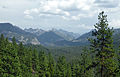 First Glimpseof the Sawtooth Range (15057823612).jpg 3,836 × 2,460; 1.58 MB
-
 Head of Grimes Creek - panoramio.jpg 3,648 × 2,736; 1.57 MB
-
 Junction Near Pilot's Peak - panoramio.jpg 3,648 × 2,736; 2.1 MB
-
 Junction near Pilots Peak - panoramio.jpg 3,648 × 2,736; 2.03 MB
-
 Looking down towards Centerville - panoramio.jpg 2,048 × 1,536; 749 KB
-
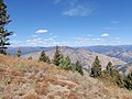 Looking North from Hole In The Wall - panoramio.jpg 3,648 × 2,736; 1.42 MB
-
 Looking north toward Deadwood - panoramio.jpg 3,648 × 2,736; 1.62 MB
-
 Looking over Hole In The Wall - panoramio.jpg 3,648 × 2,736; 1.55 MB
-
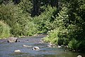 Mores Creek along the Ponderosa Scenic Byway - panoramio.jpg 3,888 × 2,592; 2.84 MB
-
 Ponderosa Pine Scenic Route, Lowman, ID 83637, USA - panoramio.jpg 2,592 × 1,936; 1.96 MB
-
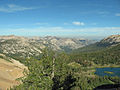
 Rendezvous Lake and South Fork Payette River.jpg 2,816 × 2,112; 3.93 MB
-
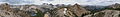 Sawtooth Panorama 1.JPG 11,889 × 1,683; 15.45 MB
-
 Sawtooths and S Fork of Payette.JPG 2,816 × 2,112; 3.75 MB
-
 Sunset Moutain - panoramio.jpg 3,648 × 2,736; 2.41 MB
-
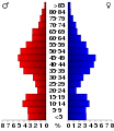 USA Boise County, Idaho age pyramid.svg 520 × 600; 9 KB
-
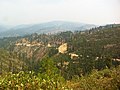
 View of Grime's Creek from Highway 21, Idaho - panoramio.jpg 3,888 × 2,592; 2.5 MB
-
 Virginia Lake Idaho.JPG 2,816 × 2,112; 4.49 MB
-
 Winding slope road (Unsplash).jpg 5,967 × 3,984; 18.88 MB


.jpg)


.jpg)
.jpg)