Category:Dalarö skans
Jump to navigation
Jump to search
| Object location | | View all coordinates using: OpenStreetMap |
|---|
it was intended to protect the inlet to the Stockholm archipelago.   | |||||
| Upload media | |||||
| Instance of |
| ||||
|---|---|---|---|---|---|
| Location | Dalarö, Haninge Municipality, Stockholm County, Sweden | ||||
| Owned by | |||||
| Operator |
| ||||
| Heritage designation |
| ||||
| Inception |
| ||||
 | |||||
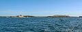
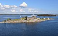
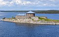
English: Media relating to the island fortress of Dalarö skans, just off the port of Dalarö in Värmdö Municipality and the Stockholm archipelago, Sweden. The island is more correctly known as Stockskärsholmen.
|
This is a category about a historic building in Sweden, number 21300000013137 in the RAÄ buildings database.
|
|
This is a category about an archaeological site or a monument in Sweden, number Dalarö 27:1 in the RAÄ Fornsök database. |
Media in category "Dalarö skans"
The following 33 files are in this category, out of 33 total.
-
 CM inspekterar Aspirantskolan Dalarö Skans.jpg 1,200 × 800; 552 KB
-
 D8E 7902 (9588719345).jpg 6,000 × 2,400; 9.91 MB
-
 D8E 7907 (9591513134).jpg 6,000 × 2,400; 8.73 MB
-
 D8E 7912 (9591512344).jpg 6,000 × 2,400; 8.56 MB
-
 D8E 7920 (9588716733).jpg 6,000 × 2,400; 9.5 MB
-
 D8E 7935 (9588714637).jpg 6,000 × 2,400; 10.64 MB
-
 D8E 7941 (9588713593).jpg 6,000 × 2,400; 9.63 MB
-
 Dalarö Fortress 2010 by Yvonne Öhrbom.jpg 3,648 × 2,736; 2.33 MB
-
 Dalarö Fortress, Sweden, 29 July 2019 - 2.jpg 5,119 × 3,413; 5.8 MB
-
 Dalarö Fortress, Sweden, 29 July 2019.jpg 5,393 × 3,595; 6.8 MB
-
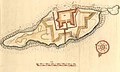
 Dalarö skans 1758.jpg 477 × 393; 54 KB
-
 Dalarö Skans 1950.jpg 600 × 426; 64 KB
-
 Dalarö Skans 2011.jpg 3,840 × 2,160; 4.42 MB
-
 Dalarö skans bredbild.jpg 3,858 × 1,346; 1.63 MB
-
 Dalarö skans broadview.jpg 827 × 180; 37 KB
-
 Dalarö Skans fyr2.jpg 1,200 × 900; 342 KB
-
 Dalarö skans ritning.jpg 4,076 × 2,460; 1.06 MB
-
 Dalarö skans, S 2355.jpg 1,944 × 1,276; 1.17 MB
-
 Dalarö Skans.jpg 640 × 480; 167 KB
-
 Dalarö skans01.jpg 1,024 × 655; 89 KB
-
 Dalarö Skans1.jpg 3,200 × 2,000; 1.04 MB
-
 Dalarö Skans2.jpg 2,400 × 1,500; 779 KB
-
 Dalarö Skans3.jpg 3,200 × 2,000; 1.12 MB
-
 Dalarö Skans4.jpg 4,000 × 2,500; 2.35 MB
-
 Dalarö Skans5.jpg 2,400 × 1,500; 812 KB
-
 Dalarö Tukholman saaristossa.jpg 2,821 × 1,729; 2.03 MB
-
 Dalarö-Skans.jpg 4,755 × 3,164; 6.52 MB
-
 Galär vid Dalarö skans, SM 27734.jpg 446 × 366; 118 KB
-
 Marinmotiv-Dalarö skans - Sjöhistoriska museet - S 2355.tif 4,003 × 2,610; 29.92 MB
-
 Marinmotiv-Galär vid Dalarö skans - Sjöhistoriska museet - O 11753.tif 3,523 × 2,568, 2 pages; 25.91 MB
-
 Per Wilhelm Cedergren-Vintermotiv från Dalarö Skans.jpg 3,370 × 2,304; 1.59 MB
-
 Sandemar fågelseservat 2012b.jpg 3,948 × 2,704; 1.74 MB
-
 Semaforering vid Dalarö skans.jpg 964 × 971; 551 KB


.jpg)
.jpg)
.jpg)
.jpg)
.jpg)
.jpg)