Category:Darfield, New Zealand
Jump to navigation
Jump to search
locality in Selwyn District, Canterbury Region, New Zealand  | |||||
| Upload media | |||||
| Instance of | |||||
|---|---|---|---|---|---|
| Location |
| ||||
| Population |
| ||||
 | |||||
Deutsch: Darfield ist eine Gemeinde im Selwyn-Distrikt der Region Canterbury auf der Südinsel Neuseelands. (→Darfield (Neuseeland))
English: Darfield is a town in the Selwyn District of the South Island of New Zealand. It is located 35 kilometres west from the outskirts of Christchurch, New Zealand on State Highway 73 (The great Alpine highway) and the town is on the Midland railway line, route of the famous TranzAlpine train service. Its population (GeoNames geographical database 2011) is 1,593. (→Darfield, New Zealand)
Nederlands: Darfield is een plaats in de regio Canterbury op het zuidereiland van Nieuw-Zeeland. Darrfield is op 45 kilometer rijden van Christchurch aan Highway 73 (de Great Alpine Highway) en ligt aan de Midland Line, een spoorwegverbinding. (→Darfield (Nieuw-Zeeland))
Norsk nynorsk: Darfield er ein by i Selwyn District på Sørøyapå New Zealand. Han ligg 45 km vest frå bygrensa til Christchurch, ved State Highway 73 (The great Alpine highway) og jarnvegslinja Midland railway line, der den kjende togruta TranzAlpine går. Folketalet var ved folketeljinga i 2006 1 485. (→Darfield på New Zealand)
Polski: Darfield – miasto na Południowej Wyspie, w Selwyn District, w Nowej Zelandia. Miasto znajduje się 45 km na zachód od przedmieść Christchurch. W roku 2001 Darfield zamieszkiwało 1 362 osób, a w 2006 1 485. (→Darfield)
Русский: Да́рфилд (. Население города (по данным переписи 2001 года) составляет 1362 человек. (→Дарфилд (Новая Зеландия))
Slovenčina: Darfield je mesto na južnom ostrove na Novom Zélande. Počet obyvateľov je 1 362 (2001). (→Darfield (Nový Zéland))
Subcategories
This category has the following 4 subcategories, out of 4 total.
Media in category "Darfield, New Zealand"
The following 8 files are in this category, out of 8 total.
-
 Darfield Butcher Shop Signs.JPG 4,000 × 6,016; 9.41 MB
-
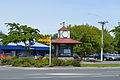 Darfield Clock.JPG 6,016 × 4,000; 9.88 MB
-
 Darfield Main Street 001.JPG 5,592 × 3,624; 6.3 MB
-
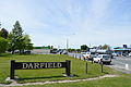 Darfield Sign and Main Street.JPG 6,016 × 4,000; 8.65 MB
-
 McHughs Forest.jpg 7,360 × 4,912; 15.69 MB
-
 Torlesse Range from Greendale Road.jpg 1,280 × 960; 227 KB
-
 Whitecliffs Branch Historical Site (1).jpg 1,280 × 960; 448 KB
-
 Whitecliffs Branch Historical Site (2).jpg 960 × 1,280; 443 KB


.jpg)
.jpg)