Category:Dartford
Sari la navigare
Sari la căutare

town in Kent, England  | |||||
| Încarcă multimedia | |||||
| Este un/o | |||||
|---|---|---|---|---|---|
| Locul actual | |||||
| Localizat pe malul | |||||
| Diferit(ă) de | |||||
 | |||||
Български: Дартфорд е град в Югоизточна Англия, графство Кент. Намира се на 25 km югоизточно от центъра на Лондон. Населението му е около 86 000 души (2001).
Deutsch: Dartford ist eine Stadt im Nordwesten der Grafschaft Kent in South East England und Verwaltungssitz des gleichnamigen Boroughs.
English: Dartford is the principal town in the borough of Dartford. It is situated in the northwest corner of Kent, England, 16 miles (25 km) east south-east of central London.
Español: Dartford es una localidad ubicada en el condado de Kent, en el sureste de Inglaterra. Según el censo del año 2001 contaba con 85.911 habitantes.
Suomi: Dartford on kaupunki Kentin kreivikunnan luoteisosassa, Englannissa. Kaupunki on myös osa Dartfordin boroughia. Asukkaita kaupungissa on 85 911 (2001).
Français : Dartford est la principale ville de l'arrondissement de Dartford. Elle est située dans la partie nord-ouest du Kent en Angleterre, à 25 km du centre de Londres, en direction de l'est-sud-est.
Italiano: Dartford è un comune inglese della contea del Kent. Nel Medioevo fu una città di commerci.
Nederlands: Dartford is een plaats in het bestuurlijke gebied Dartford, in het Engelse graafschap Kent. De plaats telt ongeveer 57.000 inwoners. Mick Jagger, de zanger van The Rolling Stones is er geboren, evenals hun gitarist Keith Richards. Ook Dick Taylor van de Pretty Things komt er vandaan.
Polski: Dartford - miasto w Anglii, w hrabstwie Kent, nad rzeką Darent. Dartford leży obecnie w regionie Londynu.
Português: 200px|right
Română: Dartford este un oraş şi un district nemetropolitan în Regatul Unit, în comitatul Kent, regiunea North West, Anglia. Districtul are o populaţie de 89.900 locuitori, din care 85.911 locuiesc în oraşul propriu zis Dartford.
Русский: Да́ртфорд — город в графстве Кент в Юго-Восточной Англии.
Subcategorii
Această categorie conține următoarele 19 subcategorii, dintr-un total de 19.
B
- Brooklands Lake (7 F)
C
D
- Dartford Heath (33 F)
E
- East Hill Cemetery (Dartford) (20 F)
F
- FM Conway (12 F)
H
J
M
- Maypole, Dartford (4 F)
P
- Priory Farmhouse, Dartford (11 F)
S
- Stone House Hospital (4 F)
T
W
Fișiere media din categoria „Dartford”
Următoarele 200 fișiere se află în această categorie, dintr-un total de 282.
(pagina anterioară) (pagina următoare)-
 "2 Buff for a Face Mask" Graffiti in the Sainsbury's Car Park, Dartford.jpg 4.592x3.448; 9,93 MB
-
 53 - 55, Spital St - geograph.org.uk - 3470596.jpg 640x430; 91 KB
-
 A section of the priory walls, Victoria Rd, Dartford.jpg 4.032x3.024; 5,71 MB
-
 A226, Highfield Rd - geograph.org.uk - 3470581.jpg 640x430; 68 KB
-
 Acacia Hall Weir - geograph.org.uk - 897189.jpg 640x481; 123 KB
-

-

-

-

-

-
 Ashen Drive Library - geograph.org.uk - 1279260.jpg 640x480; 66 KB
-

-
 B2500 Bridge, A282 - geograph.org.uk - 3307351.jpg 640x430; 49 KB
-
 Bandstand, Central Park - geograph.org.uk - 3478619.jpg 640x430; 63 KB
-
 Baptist Church - geograph.org.uk - 3470576.jpg 640x430; 66 KB
-
 Bingo Hall, Spital St - geograph.org.uk - 3470605.jpg 640x430; 69 KB
-
 Blackmans Close - geograph.org.uk - 3470555.jpg 640x430; 49 KB
-
 Bridge House - geograph.org.uk - 897028.jpg 640x461; 76 KB
-

-
 Brooklands Lake - geograph.org.uk - 3485655.jpg 640x430; 76 KB
-
 Brooklands Lake - geograph.org.uk - 3485677.jpg 640x430; 78 KB
-
 Bulls Head Yard - geograph.org.uk - 3475586.jpg 640x430; 75 KB
-
 Burnt Out Car in the Dark Trees, Dartford.jpg 4.356x3.243; 18,18 MB
-
 Burrough's Wellcome & Co Manufacturing Wellcome L0034060.jpg 2.460x1.926; 1,24 MB
-
 Burroughs Wellcome & Co factory, Dartford Wellcome M0008495.jpg 4.730x2.444; 2,53 MB
-
 Burroughs Wellcome & Co factory, Dartford Wellcome M0008496.jpg 3.978x2.664; 1,59 MB
-

-
 Caning Log for Wilmington Grammar School for Boys - Alexa.png 2.308x1.624; 41 KB
-
-
 Central Park - geograph.org.uk - 3475753.jpg 640x430; 105 KB
-
 Central Park - geograph.org.uk - 3478612.jpg 640x430; 122 KB
-
 Central Park - geograph.org.uk - 3478624.jpg 640x430; 98 KB
-
 Central Park - geograph.org.uk - 3478639.jpg 640x430; 46 KB
-
 Central Park - geograph.org.uk - 3478648.jpg 640x430; 68 KB
-
 Chapel Court - geograph.org.uk - 1175346.jpg 640x481; 76 KB
-
 Chapel, Watling Street Cemetery, Dartford 01.jpg 4.032x3.024; 4,51 MB
-
 Chapel, Watling Street Cemetery, Dartford 02.jpg 4.032x3.024; 5,17 MB
-

-
 Church Court - geograph.org.uk - 3470584.jpg 640x430; 81 KB
-
 Closed Footbridge - geograph.org.uk - 1175304.jpg 640x481; 96 KB
-
 CMAC; SA-MAC-J.4-6 Wellcome L0024401.jpg 1.596x1.192; 647 KB
-

-

-
 Costa Coffee Dartford.jpg 4.000x2.672; 2,98 MB
-
 Darent Valley Path - geograph.org.uk - 3485671.jpg 640x430; 147 KB
-
 Darent Valley Path at Otford Kent UK sign.JPG 1.287x1.215; 1,21 MB
-

-

-
 Darent Valley Path, Central Park - geograph.org.uk - 3478642.jpg 430x640; 104 KB
-

-

-

-
 Dartford Bridge (Home Gardens), 8 March 2014.jpg 480x640; 56 KB
-
 Dartford Bridge - geograph.org.uk - 897041.jpg 640x481; 106 KB
-
 Dartford Civic Centre (Home Gardens), 8 March 2014.jpg 480x640; 46 KB
-
 Dartford Creek - geograph.org.uk - 1169600.jpg 640x481; 85 KB
-
 Dartford Grammar School.jpg 4.032x3.024; 7,31 MB
-
 Dartford High Street LCCN96516927.jpg 4.096x3.271; 2,27 MB
-
 Dartford High Street LCCN96516927.tif 4.096x3.271; 12,78 MB
-
 Dartford Library - geograph.org.uk - 3475690.jpg 640x430; 50 KB
-
 Dartford Library - geograph.org.uk - 3475699.jpg 640x430; 77 KB
-
 Dartford Lions Club shed - geograph.org.uk - 3470550.jpg 640x430; 97 KB
-
 Dartford Market - geograph.org.uk - 894690.jpg 640x481; 84 KB
-

-
 Dartford Railway Station under development - geograph.org.uk - 3259374.jpg 4.288x3.216; 4,91 MB
-

-
 Dartford unparished area UK locator map.svg 1.279x1.266; 258 KB
-

-

-
 Dartford, DA1 - East Hill - geograph.org.uk - 3179690.jpg 3.253x2.961; 1,91 MB
-

-

-
 Dartford, from St Edmunds Pleasance.JPG 3.240x4.320; 5 MB
-
 Dartford, Kent, England, 3 Sept. 2011 - Flickr - PhillipC.jpg 3.810x2.366; 2,31 MB
-

-
 Dartford3798.JPG 2.848x2.136; 1,33 MB
-
 DartfordCivicCentre4836.JPG 2.048x1.536; 777 KB
-
 DartfordDarent3793.JPG 2.848x2.136; 1,32 MB
-
 DartfordDarent3794.JPG 2.848x2.136; 1,36 MB
-
 DartfordDarent3795.JPG 2.848x2.136; 1,26 MB
-
 DartfordEastHill4889(edited).JPG 2.003x1.450; 392 KB
-
 DartfordHolyTrinityDarent4891.JPG 2.048x1.536; 781 KB
-
 Dartfordmap1945.jpg 3.504x2.544; 1,92 MB
-
 DartfordOrchard4879(edited).JPG 2.006x1.204; 283 KB
-
 DartfordOrchard4881.JPG 2.048x1.536; 758 KB
-
 DartfordOrchard4882.JPG 2.048x1.536; 748 KB
-
 DartfordOrchard4883.JPG 2.048x1.536; 786 KB
-
 DartfordOrchard4884.JPG 2.048x1.536; 769 KB
-
 DartfordOrchardBridge4855.JPG 2.048x1.536; 786 KB
-
 DartfordOrchardBridge4856.JPG 2.048x1.536; 814 KB
-
 DartfordOrchardBridge4857.JPG 2.048x1.536; 785 KB
-
 DartfordPriory4873(edited).JPG 2.016x1.311; 297 KB
-
 DartfordPriory4876.JPG 2.048x1.536; 761 KB
-
 DartfordPriory4877.JPG 2.048x1.536; 748 KB
-
 DartfordPriory4878.JPG 2.048x1.536; 755 KB
-
 DartfordProspect4868.JPG 2.048x1.536; 773 KB
-
 DartfordProspect4870c.JPG 1.907x1.305; 304 KB
-
 David Leal and the SB Decima at Dartford Lock 8748.jpg 4.608x3.456; 3,43 MB
-

-
-
 Driftwood beside river sea wall - geograph.org.uk - 1169657.jpg 640x481; 116 KB
-
 Dyke in Dartford Marshes - geograph.org.uk - 1169540.jpg 640x481; 95 KB
-
 Electrical Sub-station - geograph.org.uk - 3475728.jpg 640x430; 91 KB
-
 Entrance to Joyden's Wood - geograph.org.uk - 1279336.jpg 640x480; 146 KB
-

-
 Filling station, Heath Rd - geograph.org.uk - 3470538.jpg 640x430; 69 KB
-
 Fleet Downs Library - geograph.org.uk - 1280556.jpg 640x480; 79 KB
-

-

-
 Flower beds - geograph.org.uk - 3478563.jpg 640x430; 84 KB
-

-

-
 Footbridge, A282 - geograph.org.uk - 3311486.jpg 640x430; 46 KB
-
 Footbridge, Central Park - geograph.org.uk - 3478645.jpg 640x430; 102 KB
-
 Footbridge, River Darent - geograph.org.uk - 3485685.jpg 640x430; 144 KB
-
 Footpath, Brooklands Lake - geograph.org.uk - 3485667.jpg 640x430; 109 KB
-

-

-
 Gartley Cottages - geograph.org.uk - 4229690.jpg 1.024x768; 131 KB
-
 Gartly Cottages, Dartford - geograph.org.uk - 3860371.jpg 3.488x2.616; 2,21 MB
-
 Gas Storage Tank - geograph.org.uk - 1323771.jpg 640x428; 80 KB
-
 Gordon Rd - geograph.org.uk - 3470569.jpg 640x430; 69 KB
-
 Halfords, Heath Lane - geograph.org.uk - 3470554.jpg 640x430; 41 KB
-
 Hanau Bridge, Dartford - geograph.org.uk - 906213.jpg 640x481; 101 KB
-
 Hardy Avenue - geograph.org.uk - 3470559.jpg 640x430; 76 KB
-
 Hesketh Park - geograph.org.uk - 1324569.jpg 640x428; 132 KB
-
 Highfield Villas - geograph.org.uk - 3470574.jpg 640x430; 71 KB
-
 Home Gardens, Dartford - geograph.org.uk - 2859761.jpg 1.280x857; 163 KB
-
 Houses in Orchard Street Dartford - geograph.org.uk - 2887551.jpg 4.000x3.000; 4,36 MB
-
 Houses on Shepherds Lane - geograph.org.uk - 2839475.jpg 640x480; 97 KB
-
 Houses on Shepherds Lane, Dartford - geograph.org.uk - 3962262.jpg 2.560x1.920; 1,99 MB
-
 Houses on the corner - geograph.org.uk - 2839477.jpg 640x480; 95 KB
-
 Hulse Memorial, St Michael & All Angels churchyard, Wilmington.jpg 4.032x3.024; 5,92 MB
-
 Iceland, Dartford - geograph.org.uk - 3475606.jpg 640x430; 76 KB
-
 Iceland, Dartford - geograph.org.uk - 3475721.jpg 640x430; 76 KB
-

-
 Industry - R Darent, Dartford - geograph.org.uk - 147471.jpg 640x480; 113 KB
-
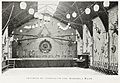 Interior of gymnasium and assembly room Wellcome L0049209.jpg 6.534x4.495; 11,09 MB
-
 James Smith VC grave.jpg 3.024x4.032; 6,66 MB
-
 James Smith VC headstone.jpg 3.024x4.032; 5,92 MB
-
 Jane Austen Plaque in the High Street, Dartford.jpg 2.862x1.916; 5,76 MB
-

-
 KFC, Dartford - geograph.org.uk - 3475651.jpg 640x430; 88 KB
-
 Lagoon on Dartford Marshes - geograph.org.uk - 1278423.jpg 640x413; 85 KB
-
 Leigh Logo Hi Res copy.png 1.211x1.588; 94 KB
-
 Littlebrook Power Station - geograph.org.uk - 1594917.jpg 640x430; 96 KB
-
 Littlebrook Power Station - geograph.org.uk - 1595537.jpg 640x433; 57 KB
-
 Littlebrook Power Station - geograph.org.uk - 1736298.jpg 4.288x2.848; 4,55 MB
-
 Livingstone Cottage Hospital, Dartford Wellcome L0033981.jpg 5.320x3.434; 6,93 MB
-
 Livingstone Cottage Hospital, Dartford, Kent. Photomechanica Wellcome V0012528.jpg 3.250x2.176; 3,91 MB
-
 Martin Luther King Image on Highfield Road, Dartford.jpg 3.831x2.844; 11,03 MB
-
 Maypole Dance at 25th Anniversary Fete, 15-07-1905 Wellcome M0013012.jpg 3.770x2.787; 3,25 MB
-

-

-
 Methodist Church - geograph.org.uk - 3470600.jpg 640x430; 83 KB
-
 Mick a Petr Zapletal 2000.jpg 1.500x954; 254 KB
-
 Mick Jagger Image along Highfield Road, Dartford.jpg 4.018x2.746; 11,58 MB
-
 Milestone outside The Royal Victoria and Bull Inn, Dartford (01).jpg 4.592x3.448; 16,17 MB
-
 Milestone outside The Royal Victoria and Bull Inn, Dartford (02).jpg 4.592x3.448; 15,43 MB
-
 Mill House, Darenth.jpg 4.032x3.024; 4,83 MB
-
 Moatfield House - geograph.org.uk - 3470566.jpg 640x430; 61 KB
-

-

-
 Off Dartford High St - geograph.org.uk - 3475594.jpg 640x430; 65 KB
-
 Office staff, group photograph Wellcome L0034058.jpg 1.925x1.539; 650 KB
-

-

-
 One Town That Changed The World.jpg 3.264x2.448; 1,62 MB
-
 Orchard Centre Clock Tower - geograph.org.uk - 894675.jpg 481x640; 64 KB
-
 Orchard Centre North Entrance - geograph.org.uk - 908926.jpg 640x481; 90 KB
-
 Orchards, Dartford - geograph.org.uk - 3475590.jpg 640x430; 89 KB
-
 Ordnance Survey Drawings - Dartford (OSD 129).jpg 4.000x2.177; 3,37 MB
-
 Ordnance Survey One-Inch Sheet 115 SE London and Dartford, Published 1934.jpg 13.606x8.998; 14,76 MB
-
 Parade of Shops - geograph.org.uk - 3470588.jpg 640x430; 74 KB
-

-
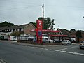 Petrol Station, Joydens Wood - geograph.org.uk - 1331946.jpg 640x480; 57 KB
-

-

-
 Pilgrims Way - geograph.org.uk - 1324516.jpg 640x423; 76 KB
-
 Power Station in Dartford - geograph.org.uk - 1027072.jpg 640x480; 56 KB
-
 Primark, Dartford - geograph.org.uk - 3475598.jpg 640x430; 85 KB
-
 Princes Park, Dartford, South Stand.jpg 1.280x800; 871 KB
-
 Princes Rd - geograph.org.uk - 3470544.jpg 640x430; 63 KB
-
 Princes Road Interchange - geograph.org.uk - 1380783.jpg 640x480; 98 KB
-
 Priory Centre, Dartford - geograph.org.uk - 897155.jpg 640x481; 93 KB
-
 Priory Centre, Dartford - geograph.org.uk - 897157.jpg 640x481; 69 KB
-
 Pylons, Crayford Marshes - geograph.org.uk - 198173.jpg 480x640; 51 KB
-

-
 Retail unit, Heath Lane - geograph.org.uk - 3470548.jpg 640x391; 50 KB
-
 Ripley's Market - geograph.org.uk - 897162.jpg 640x481; 88 KB
-
 River Darent - geograph.org.uk - 3478654.jpg 640x430; 113 KB
-
 River Darent - geograph.org.uk - 3478687.jpg 640x430; 126 KB
-
 River Darent - geograph.org.uk - 3478787.jpg 640x430; 107 KB
-
 River Darent lock - geograph.org.uk - 147462.jpg 640x480; 125 KB
-

-
 Riverside Steps - geograph.org.uk - 897868.jpg 640x481; 105 KB
-

-
 Royal Victoria ^ Bull Hotel - geograph.org.uk - 3475575.jpg 640x430; 84 KB
-
 Sainsbury's, Dartford - geograph.org.uk - 897164.jpg 640x481; 66 KB
-
 SB Decima at Dartford Lock 8716.jpg 4.608x3.456; 3,36 MB


_-_NARA_-_20803878.jpg)
_-_NARA_-_20803886.jpg)


,_8_March_2014.jpg)

,_8_March_2014.jpg)


_-_geograph.org.uk_-_717910.jpg)
_-_geograph.org.uk_-_717928.jpg)


.JPG)


.JPG)


.JPG)


.jpg)
.jpg)


.jpg)


,_studies_a_book_on_air_navigation_in_a_bookshop_in_his_home_town_of_Dartford_in_Kent,_26_April_1942._CH10981.jpg)


.JPG)