Category:De Dellen, Nieuw-Scheemda
Jump to navigation
Jump to search
| Object location | | View all coordinates using: OpenStreetMap |
|---|
windmill in Nieuw-Scheemda, Netherlands _(cropped).jpg) | |||||
| Upload media | |||||
| Instance of | |||||
|---|---|---|---|---|---|
| Location | Nieuw-Scheemda, Oldambt, Groningen, Netherlands | ||||
| Has use |
| ||||
| Heritage designation |
| ||||
| Source of energy | |||||
 | |||||
|
This is a category about rijksmonument number 33080
|
| Address |
|
Media in category "De Dellen, Nieuw-Scheemda"
The following 22 files are in this category, out of 22 total.
-

-

-

-

-

-
 De Dellen achterkant.JPG 2,304 × 3,072; 2.31 MB
-
 De Dellen bord.JPG 3,072 × 2,304; 2.45 MB
-
 De Dellen.JPG 2,304 × 3,072; 2.67 MB
-
 Exterieur EEN DER AFGEDANKTE VOEGHOUTEN - Scheemda - 20290132 - RCE.jpg 1,200 × 1,200; 330 KB
-
 Exterieur IN RESTAURATIE - Scheemda - 20290127 - RCE.jpg 1,200 × 1,200; 227 KB
-
 Exterieur IN RESTAURATIE - Scheemda - 20290128 - RCE.jpg 1,200 × 1,195; 268 KB
-
 Exterieur IN RESTAURATIE - Scheemda - 20290129 - RCE.jpg 1,200 × 1,200; 238 KB
-
 Exterieur IN RESTAURATIE - Scheemda - 20290130 - RCE.jpg 1,200 × 1,200; 305 KB
-

-
 Exterieur OVERZICHT (TIJDENS RESTAURATIE) - Scheemda - 20292745 - RCE.jpg 1,200 × 1,195; 184 KB
-
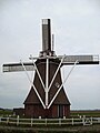
 Molen De Dellen (38362645816) (cropped).jpg 962 × 1,024; 927 KB
-
 Molen De Dellen (38362645816).jpg 1,536 × 1,024; 1.09 MB
-
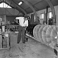 Molenaar teert de nieuwe vijzel - Nieuw-Scheemda - 20290133 - RCE.jpg 1,200 × 1,200; 278 KB
-
 Nieuwe plaats voor molen "De Dellen" - Scheemda - 20195439 - RCE.jpg 1,200 × 1,197; 299 KB
-
 Nieuwe plaats voor molen "De Dellen", overzicht. - Scheemda - 20195440 - RCE.jpg 1,200 × 1,200; 319 KB
-
 Poldermolen "De Dellen", funderingspalen voor de molen. - Scheemda - 20195441 - RCE.jpg 1,200 × 1,200; 302 KB
-


_-_Scheemda_-_20292745_-_RCE.jpg)
.jpg)


