Category:De Lastdrager
Jump to navigation
Jump to search
| Object location | | View all coordinates using: OpenStreetMap |
|---|
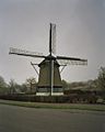
windmill in Hoogwoud, Netherlands  | |||||
| Upload media | |||||
| Instance of |
| ||||
|---|---|---|---|---|---|
| Location | Hoogwoud, North Holland, Netherlands | ||||
| Street address |
| ||||
| Located on street |
| ||||
| Has use | |||||
| Heritage designation |
| ||||
| Source of energy | |||||
 | |||||
|
This is a category about rijksmonument number 31788
|
| Address |
|
Media in category "De Lastdrager"
The following 17 files are in this category, out of 17 total.
-
 Heechwâld, nôtmûne 'De Lastdrager'.jpg 3,594 × 3,600; 4.99 MB
-
 Hoogwoud - molen De Lastdrager in late namiddag.jpg 1,215 × 1,300; 793 KB
-
 Hoogwoud. Molen De Lastdrager..JPG 1,600 × 1,067; 250 KB
-
 Korenmolen "De Lastdrager", bebouwing rond de molen - Hoogwoud - 20115507 - RCE.jpg 1,200 × 1,158; 364 KB
-

-
 Korenmolen "De Lastdrager", omgeving - Hoogwoud - 20115506 - RCE.jpg 1,200 × 1,165; 336 KB
-
 Korenmolen "De Lastdrager", onthulling naambord - Hoogwoud - 20115511 - RCE.jpg 1,200 × 1,179; 224 KB
-
 Korenmolen De Lastdrager, overzicht - Hoogwoud - 20115517 - RCE.jpg 1,200 × 1,200; 216 KB
-
 Korenmolen De Lastdrager, overzicht vervallen bijgebouw. - Hoogwoud - 20115518 - RCE.jpg 1,200 × 1,200; 228 KB
-
-
 Lastdrager, Hoogwoud.jpg 1,456 × 2,592; 1.26 MB
-
 Molen "De Lastdrager", Koningspark - Hoogwoud - 20115505 - RCE.jpg 802 × 1,200; 231 KB
-
 Molen, aanzicht - Hoogwoud - 20115508 - RCE.jpg 1,200 × 883; 140 KB
-
 Molen, aanzicht - Hoogwoud - 20115509 - RCE.jpg 1,200 × 875; 167 KB
-
 Molen, overzicht - Hoogwoud - 20115501 - RCE.jpg 1,200 × 1,183; 369 KB
-
 Ontsierde bebouwing en hoge bomen bij molen. - Hoogwoud - 20115499 - RCE.jpg 1,200 × 1,179; 331 KB
-
 Ontsierde bebouwing en hoge bomen bij molen. - Hoogwoud - 20115500 - RCE.jpg 1,200 × 1,174; 268 KB


