Category:De Leeuw, Zeerijp
Jump to navigation
Jump to search
| Object location | | View all coordinates using: OpenStreetMap |
|---|
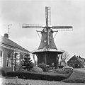
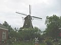
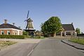
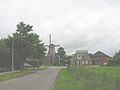
windmill in Zeerijp, Netherlands  | |||||
| Upload media | |||||
| Instance of | |||||
|---|---|---|---|---|---|
| Location | Zeerijp, Eemsdelta, Groningen, Netherlands | ||||
| Street address |
| ||||
| Located on street |
| ||||
| Has use | |||||
| Heritage designation |
| ||||
| Source of energy | |||||
 | |||||
|
This is a category about rijksmonument number 40305
|
| Address |
|
Media in category "De Leeuw, Zeerijp"
The following 28 files are in this category, out of 28 total.
-
 Aanzicht met korenmolen - Zeerijp - 20221199 - RCE.jpg 1,197 × 1,200; 268 KB
-
 Aanzicht met korenmolen - Zeerijp - 20221200 - RCE.jpg 1,197 × 1,200; 258 KB
-

-

-

-

-
-

-

-

-
 Koren- en pelmolen "De Leeuw" - Zeerijp - 20221203 - RCE.jpg 1,200 × 1,179; 238 KB
-
 Koren- en pelmolen "De Leeuw" - Zeerijp - 20221204 - RCE.jpg 1,200 × 1,170; 237 KB
-
 Korenmolen "De Leeuw", in restauratie - Zeerijp - 20221205 - RCE.jpg 1,200 × 1,168; 274 KB
-
 Korenmolen "De Leeuw", overzicht - Zeerijp - 20221206 - RCE.jpg 1,200 × 1,175; 249 KB
-
 Korenmolen "De Leeuw", overzicht - Zeerijp - 20221207 - RCE.jpg 1,200 × 1,179; 215 KB
-
 Molen - Zeerijp - 20221202 - RCE.jpg 872 × 1,200; 228 KB
-
 Molen de Leeuw Zeerijp.jpg 972 × 1,296; 342 KB
-
 Molen, overzicht - Zeerijp - 20221208 - RCE.jpg 1,200 × 948; 284 KB
-
 Overzicht van de molen - Zeerijp - 20420662 - RCE.jpg 800 × 1,200; 155 KB
-
 Overzicht van de molen - Zeerijp - 20420663 - RCE.jpg 1,200 × 800; 232 KB
-
 Overzicht van de molen - Zeerijp - 20420664 - RCE.jpg 1,200 × 800; 150 KB
-
 Overzicht van de molen - Zeerijp - 20420665 - RCE.jpg 1,200 × 800; 261 KB
-
 Overzicht van de molen - Zeerijp - 20420666 - RCE.jpg 800 × 1,200; 147 KB
-
 Overzicht van de molen - Zeerijp - 20420667 - RCE.jpg 1,200 × 800; 166 KB
-
 Vergezicht met achtkante stellingmolen - AMR Molenfoto - 20541567 - RCE.jpg 1,200 × 900; 88 KB
-
-
 Zeerijp 901.jpg 2,592 × 3,888; 2.2 MB
-
 Zeerijp 904.JPG 2,570 × 3,855; 6.67 MB


