Category:De Swaen, Nieuw-Beijerland
Jump to navigation
Jump to search
| Object location | | View all coordinates using: OpenStreetMap |
|---|
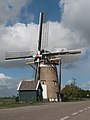
windmill in Nieuw-Beijerland, Netherlands  | |||||
| Upload media | |||||
| Instance of |
| ||||
|---|---|---|---|---|---|
| Location | Nieuw-Beijerland, Hoeksche Waard, South Holland, Netherlands | ||||
| Street address |
| ||||
| Located on street |
| ||||
| Has use | |||||
| Heritage designation |
| ||||
| Source of energy | |||||
 | |||||
|
This is a category about rijksmonument number 30393
|
| Address |
|
Media in category "De Swaen, Nieuw-Beijerland"
The following 11 files are in this category, out of 11 total.
-

-
 Hoeksche Waard Nieuw-Beijerland, Molen De Swaen RM30393 IMG 2540 2022-07-11 14.02.jpg 5,472 × 3,648; 9.76 MB
-
 Korenmolen "De Zwaan", aanzicht - Nieuw-Beijerland - 20164136 - RCE.jpg 1,200 × 1,176; 165 KB
-
 Korenmolen "De Zwaan", aanzicht - Nieuw-Beijerland - 20164137 - RCE.jpg 1,200 × 1,171; 201 KB
-
 Nieuw Beijerland, windmolen de Swaan RM30393 foto2 2014-04-14 15.24.jpg 3,312 × 4,416; 7.92 MB
-
 Nieuw-Beijerland molen De Swaen bij nacht.jpg 1,000 × 1,500; 891 KB
-
 Nieuw-Beijerland molen De Swaen vanaf de dijk.jpg 1,400 × 2,100; 1.72 MB
-
 Nieuw-Beijerland molen De Swaen.jpg 1,547 × 2,100; 1.75 MB
-
 Nieuw-beijerland,june 2010 (4) (8156397352).jpg 3,000 × 4,000; 2.59 MB
-
 Nieuw-beijerland,june 2010 (5) (8156389268).jpg 2,627 × 3,490; 2.62 MB
-
 Windmill nieuw-beijerland (8488475045).jpg 2,987 × 3,123; 1.92 MB


_(8156397352).jpg)
_(8156389268).jpg)
.jpg)