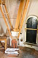
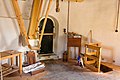
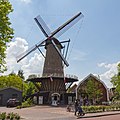
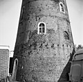
Category:De Volharding (Best)
Jump to navigation
Jump to search
| Object location | | View all coordinates using: OpenStreetMap |
|---|
windmill in Best, Netherlands  | |||||
| Upload media | |||||
| Instance of | |||||
|---|---|---|---|---|---|
| Location | Best, North Brabant, Netherlands | ||||
| Street address |
| ||||
| Has use | |||||
| Heritage designation |
| ||||
| Source of energy | |||||
 | |||||
|
This is a category about rijksmonument number 9437
|
| Address |
|
Media in category "De Volharding (Best)"
The following 18 files are in this category, out of 18 total.
-
 2007-09-16 12.02 Best, voormalige molen.JPG 3,072 × 2,304; 2.38 MB
-
 Best - Molen De Volharding molendag 2019-8477.jpg 3,456 × 4,838; 1.59 MB
-
 Best - Molen De Volharding molendag 2019-8485.jpg 3,456 × 5,184; 1.88 MB
-
 Best - Molen De Volharding molendag 2019-8486.jpg 5,184 × 3,456; 1.5 MB
-
 Best - Molen De Volharding molendag 2019-8487.jpg 5,184 × 3,456; 1.86 MB
-
 Best - Molen De Volharding molendag 2019-8488.jpg 5,184 × 3,456; 1.78 MB
-
 Best - Molen De Volharding molendag 2019-8491.jpg 3,456 × 5,184; 1.73 MB
-
 Best - Molen De Volharding molendag 2019-8495.jpg 3,339 × 3,339; 1.48 MB
-
 Best - Molen De Volharding molendag 2019-8496.jpg 3,049 × 4,268; 1.59 MB
-
 Best - Molen De Volharding molendag 2019-8497.jpg 3,456 × 3,456; 1.89 MB
-
 Best - Molen De Volharding molendag 2019-8498.jpg 3,279 × 4,590; 1.91 MB
-
 H.Hartstraat, Molen - Best - 20034102 - RCE.jpg 802 × 1,200; 147 KB
-
 Korenmolen aan de H.Hartstraat, detail - Best - 20034159 - RCE.jpg 1,200 × 1,179; 355 KB
-
 Korenmolen aan de H.Hartstraat, detail - Best - 20034160 - RCE.jpg 1,200 × 1,174; 231 KB
-
 Korenmolen aan de H.Hartstraat, overzicht - Best - 20034158 - RCE.jpg 1,200 × 1,190; 255 KB
-
 Korenmolen, overzicht - Best - 20034161 - RCE.jpg 1,200 × 1,183; 226 KB
-
 Korenmolen, overzicht - Best - 20034162 - RCE.jpg 1,198 × 1,200; 220 KB
-
 Korenmolen, overzicht - Best - 20034163 - RCE.jpg 1,200 × 1,179; 381 KB


