Category:Den Oordt, Ommen
Jump to navigation
Jump to search
| Object location | | View all coordinates using: OpenStreetMap |
|---|
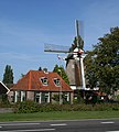
windmill in Ommen, Netherlands | |||||
| Upload media | |||||
| Instance of | |||||
|---|---|---|---|---|---|
| Location | Ommen, Overijssel, Netherlands | ||||
| Street address |
| ||||
| Located on street |
| ||||
| Has use | |||||
| Heritage designation |
| ||||
| Source of energy | |||||
 | |||||
Nederlands: De molen op Den Oordt in het Overijsselse Ommen is een van de weinige resterende zeskante windmolens in Nederland. De molen is afkomstig uit de Zaanstreek en zou ook nog in Bathmen hebben gestaan.
|
This is a category about rijksmonument number 31479
|
| Address |
|
Media in category "Den Oordt, Ommen"
The following 19 files are in this category, out of 19 total.
-
31479 Ommen molen Den Oordt 06.jpg 2,304 × 2,551; 2.43 MB
-
Houtzaag-korenmolen - Ommen - 20173297 - RCE.jpg 901 × 1,200; 183 KB
-
Houtzaagmolen, aanzicht - Ommen - 20173298 - RCE.jpg 790 × 1,200; 170 KB
-
Korenmolen, aanzicht - Ommen - 20173312 - RCE.jpg 953 × 1,200; 242 KB
-
Molen - Ommen - 20173331 - RCE.jpg 1,200 × 800; 140 KB
-
Ommen molen Den Oordt.jpg 1,312 × 1,968; 1.4 MB
-
Ommen, de molen op Den Oordt RM31479 foto4 2014-10-04 16.20.jpg 3,264 × 4,352; 9.91 MB
-
Overzicht van de molen in verval, voor de restauratie - Ommen - 20369808 - RCE.jpg 3,090 × 3,090; 2.32 MB
-
Overzicht van de molen met een roe - Ommen - 20369807 - RCE.jpg 3,090 × 3,090; 1.87 MB
-
Overzicht van de molen, na de restauratie - Ommen - 20369810 - RCE.jpg 3,090 × 3,086; 1.78 MB
-
Voorgevel overzicht - Ommen - 20173258 - RCE.jpg 1,192 × 1,200; 287 KB
-
Voormalige houtzaagmolen "Den Oordt", exterieur - Ommen - 20173303 - RCE.jpg 1,199 × 1,200; 318 KB
-
Voormalige houtzaagmolen "Den Oordt", overzicht - Ommen - 20173302 - RCE.jpg 1,197 × 1,200; 239 KB
-
Zaagmolen, kruihaspel - Ommen - 20173299 - RCE.jpg 3,113 × 3,054; 1.73 MB


