Category:Dolmen de la Pierre Laye
Jump to navigation
Jump to search
| Object location | | View all coordinates using: OpenStreetMap |
|---|
|
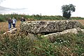
This building is classé au titre des monuments historiques de la France. It is indexed in the base Mérimée, a database of architectural heritage maintained by the French Ministry of Culture, under the reference PA00115966
|
dolmen in Vauxrezis, France .jpg) | |||||
| Upload media | |||||
| Instance of | |||||
|---|---|---|---|---|---|
| Location | Vauxrezis, Aisne, Hauts-de-France, Metropolitan France, France | ||||
| Heritage designation |
| ||||
 | |||||
Media in category "Dolmen de la Pierre Laye"
The following 2 files are in this category, out of 2 total.
-
 Dolmen de la Pierre-Laye (Aisne, Picardie, France).jpg 5,472 × 3,648; 1.68 MB
-
 Pierre-Laye (gravure).jpg 807 × 554; 252 KB
.jpg)