Category:Dolmen de Penhap
Jump to navigation
Jump to search
| Object location | | View all coordinates using: OpenStreetMap |
|---|
|
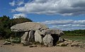
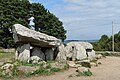
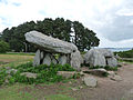
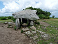
This building is classé au titre des monuments historiques de la France. It is indexed in the base Mérimée, a database of architectural heritage maintained by the French Ministry of Culture, under the reference PA00091303
|
dolmen in Île-aux-Moines, France .jpg) | |||||
| Upload media | |||||
| Instance of | |||||
|---|---|---|---|---|---|
| Location | Île-aux-Moines, canton of Vannes-Ouest | ||||
| Street address |
| ||||
| Heritage designation |
| ||||
 | |||||
Media in category "Dolmen de Penhap"
The following 23 files are in this category, out of 23 total.
-
 Breizh 56 - enizenac'h - penn hap 01.JPG 2,592 × 1,601; 1.24 MB
-
 Breizh 56 - enizenac'h - penn hap 02.JPG 1,617 × 1,000; 367 KB
-
 Dolmen de Penhap - île aux Moines - 01.jpg 5,610 × 3,610; 17.4 MB
-
 Dolmen de Penhap - île aux Moines - 02.jpg 5,689 × 3,779; 18.44 MB
-
 Dolmen de Penhap - île aux Moines - 03.jpg 5,058 × 3,351; 14.99 MB
-
 Dolmen de Penhap - île aux Moines - 04.jpg 6,016 × 4,016; 20.27 MB
-
 Dolmen de Penhap - île aux Moines - 05.jpg 6,016 × 4,016; 20.04 MB
-
 Dolmen de Penhap - île aux Moines - 06.jpg 5,678 × 3,780; 20.17 MB
-
 Dolmen de Penhap - île aux Moines - 07.jpg 6,016 × 4,016; 21.77 MB
-
 Dolmen de Penhap - île aux Moines - 08.jpg 5,520 × 3,685; 17.37 MB
-
 Dolmen de Penhap Ile aux Moines 01.jpg 5,472 × 3,648; 5.11 MB
-
 Dolmen de Penhap Ile aux Moines 02.jpg 5,472 × 3,648; 6.01 MB
-
 Dolmen de Penhap Ile aux Moines 03.jpg 5,472 × 3,648; 5.71 MB
-
 Dolmen de Penhap.jpg 2,272 × 1,704; 365 KB
-
 Le dolmen de Penhap 1923.jpg 1,592 × 981; 1.17 MB
-
 Penhap dolmen 2 Île-aux-Moines.jpg 1,577 × 903; 951 KB
-
 Penhap dolmen Île-aux-Moines.jpg 1,545 × 1,147; 1.29 MB
-
 Île-aux-Moines-Dolmen de Penhap (1).jpg 3,648 × 2,736; 2.62 MB
-
 Île-aux-Moines-Dolmen de Penhap (2).jpg 2,736 × 3,648; 2.91 MB
-
 Île-aux-Moines-Dolmen de Penhap (3).jpg 3,648 × 2,736; 2.43 MB
-
 Île-aux-Moines-Dolmen de Penhap (4).jpg 3,648 × 2,736; 2.5 MB
-
 Île-aux-Moines-Dolmen de Penhap (5).jpg 3,648 × 2,736; 2.97 MB
-
 Île-aux-Moines-Dolmen de Penhap (6).jpg 3,648 × 2,736; 2.41 MB


.jpg)
.jpg)
.jpg)
.jpg)
.jpg)