Category:Dolmen de Saillant (Saint-Nectaire)
Jump to navigation
Jump to search
| Object location | | View all coordinates using: OpenStreetMap |
|---|
|
This building is classé au titre des monuments historiques de la France. It is indexed in the base Mérimée, a database of architectural heritage maintained by the French Ministry of Culture, under the reference PA00092375
|
 | |||||
| Upload media | |||||
| Instance of | |||||
|---|---|---|---|---|---|
| Location | Saint-Nectaire, canton of Champeix | ||||
| Street address |
| ||||
| Heritage designation |
| ||||
 | |||||
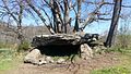
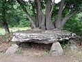
Français : Dolmen près du village de Saillant, commune de Saint-Nectaire, Puy-de-Dôme, France.
Media in category "Dolmen de Saillant (Saint-Nectaire)"
The following 8 files are in this category, out of 8 total.
-
 Dolmen de Saillant 01.jpg 4,128 × 2,322; 5.63 MB
-
 Dolmen de Saillant 02.jpg 4,128 × 2,322; 5.62 MB
-
 Dolmen de Saillant 03.jpg 4,128 × 2,322; 5.65 MB
-
 Dolmen de Saillant 04.jpg 4,128 × 2,322; 5.66 MB
-
 Saillant Dolmen1.JPG 2,560 × 1,920; 1.89 MB
-
 Saillant Dolmen2.JPG 2,560 × 1,920; 1.86 MB
-
 Saillant Dolmen3.JPG 2,560 × 1,920; 1.85 MB
-
 Saint-Nectaire dolmen Saillant.JPG 3,264 × 2,448; 3.96 MB


