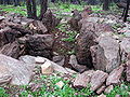
Category:Dolmen de l'Agriotier
Jump to navigation
Jump to search
| Object location | | View all coordinates using: OpenStreetMap |
|---|
| Upload media | |||||
| Instance of | |||||
|---|---|---|---|---|---|
| Location | Roquebrune-sur-Argens, canton of Le Muy | ||||
 | |||||
Media in category "Dolmen de l'Agriotier"
The following 2 files are in this category, out of 2 total.
-
 Roquebrune dolmen agriotier 01.jpg 2,048 × 1,536; 1.22 MB
-
 Roquebrune dolmen agriotier 02.jpg 2,048 × 1,536; 1.15 MB

