Category:Dommitzsch, Commende 8
Jump to navigation
Jump to search
| Object location | | View all coordinates using: OpenStreetMap |
|---|
| (Wikidata) |
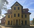
Deutsch: Herrenhaus eines ehemaligen Rittergutes in Dommitzsch, Commende 8; erbaut 1881; historistischer Putzbau über kreuzförmigem Grundriss, ortsgeschichtliche und baugeschichtliche Bedeutung; Kulturdenkmal
English: Mansion of a former manor in Dommitzsch, Commende 8; built in 1881; historicistic plaster building on a cross-shaped floor plan, local history and building history of importance; cultural heritage monument
house in Dommitzsch, Germany | |||||
| Upload media | |||||
| Instance of | |||||
|---|---|---|---|---|---|
| Location | Dommitzsch, Nordsachsen, Saxony, Germany | ||||
| Street address |
| ||||
| Heritage designation | |||||
| Inception |
| ||||
 | |||||
Media in category "Dommitzsch, Commende 8"
The following 10 files are in this category, out of 10 total.
-
 Dommitzsch, Commende 8 (01).jpg 3,528 × 2,932; 5.3 MB
-
 Dommitzsch, Commende 8 (02).jpg 3,726 × 2,795; 6.56 MB
-
 Dommitzsch, Commende 8 (03).jpg 3,654 × 2,920; 7.19 MB
-
 Dommitzsch, Commende 8 (04).jpg 4,542 × 4,054; 3.03 MB
-
 Dommitzsch, Commende 8 (05).jpg 3,648 × 3,002; 6.29 MB
-
 Dommitzsch, Commende 8 (06).jpg 3,586 × 2,690; 5.74 MB
-
 Dommitzsch, Commende 8 (07).jpg 3,748 × 2,948; 6.98 MB
-
 Dommitzsch, Commende 8 (08).jpg 3,024 × 4,032; 1.29 MB
-
 Dommitzsch, Commende 8 (09).jpg 3,556 × 2,918; 6.14 MB
-
 Dommitzsch, Commende 8 (10).jpg 3,528 × 2,926; 6.86 MB
.jpg)
.jpg)
.jpg)
.jpg)
.jpg)
.jpg)
.jpg)
.jpg)
.jpg)
.jpg)