Category:Dommitzsch, Durchlass Mühlgraben
Jump to navigation
Jump to search
| Object location | | View all coordinates using: OpenStreetMap |
|---|
| (Wikidata) |
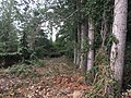
Deutsch: Durchlass des Mühlgrabens in Dommitzsch, an der Eisenbahnstrecke Pratau (Pretzsch) – Torgau, km 89,51; streckentypische Ausführung mit Sandsteinquadern und einer Bogenkonstruktion aus Klinkern, mit Flügelmauern eingeschlossen im Damm; verkehrsgeschichtlich von Bedeutung; Kulturdenkmal
English: Flow passage of the Mühlgraben in Dommitzsch, on the Pratau (Pretzsch) - Torgau railway line, km 89.51; route typical construction with sandstone blocks and a clinker arch construction with wing walls enclosed in the dam; traffic history of importance; cultural heritage monument
culvert in Dommitzsch in Germany .jpg) | |||||
| Upload media | |||||
| Instance of | |||||
|---|---|---|---|---|---|
| Part of | |||||
| Location | Dommitzsch, Nordsachsen, Saxony, Germany | ||||
| Street address |
| ||||
| Crosses | |||||
| Heritage designation | |||||
| Inception |
| ||||
 | |||||
Media in category "Dommitzsch, Durchlass Mühlgraben"
The following 7 files are in this category, out of 7 total.
-
 Dommitzsch, Durchlass Mühlgraben (1).jpg 4,032 × 3,024; 3.92 MB
-
 Dommitzsch, Durchlass Mühlgraben (2).jpg 4,032 × 3,024; 3.83 MB
-
 Dommitzsch, Durchlass Mühlgraben (3).jpg 4,032 × 3,024; 3.88 MB
-
 Dommitzsch, Durchlass Mühlgraben (4).jpg 4,032 × 3,024; 5.06 MB
-
 Dommitzsch, Durchlass Mühlgraben (5).jpg 4,032 × 3,024; 4.08 MB
-
 Dommitzsch, Durchlass Mühlgraben (6).jpg 4,032 × 3,024; 3.87 MB
-
 Dommitzsch, Durchlass Mühlgraben (7).jpg 4,032 × 3,024; 3.44 MB
.jpg)
.jpg)
.jpg)
.jpg)
.jpg)
.jpg)