Category:Dommitzsch, Kirchstraße 3
Jump to navigation
Jump to search
| Object location | | View all coordinates using: OpenStreetMap |
|---|
| (Wikidata) |
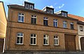
Deutsch: Ackerbürgerhaus in halboffener Bebauung in Dommitzsch, Kirchstraße 3, gebaut Ende 19. Jh., Klinkerfassade mit großer Toreinfahrt, zweigeschossiger Klinkerbau mit Satteldach, baugeschichtlich, ortsgeschichtlich und ortsbildprägend von Bedeutung; Kulturdenkmal
English: Residential house of [field] farming town citizens in ajar development Dommitzsch, Kirchstraße 3, built at the end of the 19th century, two-storey brick construction with gable roof, clinker façade with large gate entrance; building history, local history and location imprinting importance; cultural heritage monument
house in Dommitzsch, Germany | |||||
| Upload media | |||||
| Instance of | |||||
|---|---|---|---|---|---|
| Location | Dommitzsch, Nordsachsen, Saxony, Germany | ||||
| Street address |
| ||||
| Heritage designation | |||||
| Inception |
| ||||
 | |||||
Media in category "Dommitzsch, Kirchstraße 3"
The following 3 files are in this category, out of 3 total.
-
 Dommitzsch, Kirchstraße 3 (1).jpg 4,032 × 3,024; 2.09 MB
-
 Dommitzsch, Kirchstraße 3 (2) stitched.jpg 6,212 × 3,962; 14.42 MB
-
 Dommitzsch, Kirchstraße 3 (2).jpg 5,764 × 3,928; 14.41 MB
.jpg)
_stitched.jpg)
.jpg)