Category:Dommitzsch, Pretzscher Straße 12
Jump to navigation
Jump to search
| Object location | | View all coordinates using: OpenStreetMap |
|---|
| (Wikidata) |
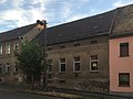
Deutsch: Taubenhaus in Dommitzsch, Pretzscher Straße 12; erbaut Ende des 19. Jh.; turmartiger Ziegelbau mit Satteldach und Freigespärre im Giebel, letztes Taubenhaus von Dommitzsch, ortsgeschichtlich und sozialgeschichtlich von Bedeutung; Kulturdenkmal
English: dovecote in Dommitzsch, Pretzscher Straße 12; built at the end of the 19th century; tower-like brick building with gable roof and jettied truss in the gable, last dovecote of Dommitzsch, local history and social history of importance; cultural heritage monument
house in Dommitzsch, Germany | |||||
| Upload media | |||||
| Instance of | |||||
|---|---|---|---|---|---|
| Location | Dommitzsch, Nordsachsen, Saxony, Germany | ||||
| Street address |
| ||||
| Heritage designation | |||||
| Inception |
| ||||
 | |||||
Media in category "Dommitzsch, Pretzscher Straße 12"
The following 4 files are in this category, out of 4 total.
-
 Dommitzsch, Pretzscher Straße 12 (1).jpg 3,587 × 2,690; 5.32 MB
-
 Dommitzsch, Pretzscher Straße 12 (2).jpg 3,686 × 2,927; 7.22 MB
-
 Dommitzsch, Pretzscher Straße 12 (3).jpg 3,426 × 2,570; 5.06 MB
-
 Dommitzsch, Pretzscher Straße 12 (4).jpg 3,640 × 2,906; 6.03 MB
.jpg)
.jpg)
.jpg)
.jpg)