Category:Dorfkirche (Bliesdorf)
Jump to navigation
Jump to search
| Object location | | View all coordinates using: OpenStreetMap |
|---|
church building in Brandenburg state, Germany  | |||||
| Upload media | |||||
| Instance of | |||||
|---|---|---|---|---|---|
| Location | Bliesdorf, Märkisch-Oderland District, Brandenburg, Germany | ||||
| Architectural style | |||||
| Heritage designation | |||||
| Inception |
| ||||
 | |||||
This is the category of the Brandenburger Baudenkmal (cultural heritage monument) with the ID 09180171 (Wikidata)
|
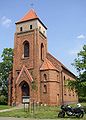
Deutsch: Die Dorfkirche in Bliesdorf, Land Brandenburg, gehört und dient einer Gemeinde der unierten Evangelischen Kirche Berlin-Brandenburg-Schlesische Oberlausitz. Die Kirche entstand 1881–1882.
English: The Village Church in Bliesdorf, Brandenburg state, Germany, is owned and used by a congregation within the Evangelical Church of Berlin-Brandenburg-Silesian Upper Lusatia, a united Protestant church body of Calvinist, Lutheran and united congregations. The church was erected in 1881–1882.
Deutsch: Bilder der Kirche in Bliesdorf, Gemeinde Bliesdorf, Landkreis Märkisch-Oderland, Land Brandenburg, Deutschland.
English: Pictures of the church in Bliesdorf, Bliesdorf municipality, Märkisch-Oderland district, Brandenburg state, Germany
Français : Photos de l'église à Bliesdorf, commune de Bliesdorf, arrondissement de Märkisch-Oderland, état fédéral de Brandebourg, Allemagne
Media in category "Dorfkirche (Bliesdorf)"
The following 5 files are in this category, out of 5 total.
-
 Bliesdorf church SE.jpg 2,850 × 2,100; 964 KB
-
 Bliesdorf church.jpg 1,230 × 1,710; 357 KB
-
 Dorfkirche Bliesdorf Denkmal.jpg 3,872 × 2,592; 5.43 MB
-
 Dorfkirche Bliesdorf.jpg 4,000 × 3,000; 7.67 MB
-
 IMG 8512BliesdorfDorfkirche.jpg 600 × 400; 87 KB


