Category:Dorfkirche (Friedersdorf im Oderland)
Jump to navigation
Jump to search
| Object location | | View all coordinates using: OpenStreetMap |
|---|
This is the category of the Brandenburger Baudenkmal (cultural heritage monument) with the ID 09180441 (Wikidata)
|
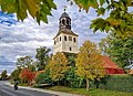
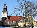
Deutsch: Die Dorfkirche in Friedersdorf im Oderland (zu Vierlinden), Mark Brandenburg, gehört und dient einer Gemeinde der unierten Evangelischen Kirche Berlin-Brandenburg-Schlesische Oberlausitz. Die Kirche entstand Mitte des 13. Jh.s und wurde 1702 grundlegend erneuert. Der Chor wurde 1945 zerstört und 1994 restauriert.
English: The Village Church in Friedersdorf (a locality of Vierlinden), March of Brandenburg, Germany, is owned and used by a congregation within the Evangelical Church of Berlin-Brandenburg-Silesian Upper Lusatia, a united Protestant church body of Calvinist, Lutheran and united congregations. The church was erected in the mid-13th c. and was thoroughly renovated in 1702. The quire was destroyed in 1945 and restored in 1994
church building in Brandenburg state, Germany  Dorfkirche Friedersdorf (2020)  Kirche in Friedersdorf, Gemeinde Vierlinden (Winter 2010)  Inneres der Kirche mit Blick nach Nordwesten auf die zweigeschossige Orgelempore | |||||
| Upload media | |||||
| Pronunciation audio | |||||
|---|---|---|---|---|---|
| Instance of | |||||
| Made from material | |||||
| Location | Friedersdorf, Vierlinden, Märkisch-Oderland District, Brandenburg, Germany | ||||
| Street address |
| ||||
| Architectural style | |||||
| Commissioned by |
| ||||
| Owned by | |||||
| Occupant | |||||
| Heritage designation | |||||
| Inception |
| ||||
| Significant event |
| ||||
| Religion or worldview | |||||
 | |||||
Media in category "Dorfkirche (Friedersdorf im Oderland)"
The following 11 files are in this category, out of 11 total.
-
 Barock Feldsteinkirche in Vierlinden OT Friedersdorf.jpg 1,417 × 2,142; 2.82 MB
-
 Friedersdorf Barockkirche im Herbst.jpg 1,962 × 1,417; 2.76 MB
-
 Friedersdorf Epitaph des Hans Georg von der Marwitz Lebus Tafel 9.jpg 4,194 × 6,271; 15.59 MB
-
 Friedersdorf Epitaph des Hans Georg von der Marwitz.jpg 2,745 × 4,426; 5.71 MB
-
 Friedersdorf Inneres der Kirche Blick nach Nordwesten Lebus Tafel 8.jpg 4,194 × 6,271; 16.05 MB
-
 Friedersdorf Inneres der Kirche Blick nach Nordwesten.jpg 3,212 × 4,014; 6.34 MB
-
 Friedersdorf, Kirche.jpg 3,054 × 2,034; 3.96 MB
-
 Friedersdorf3.JPG 2,272 × 1,704; 3.62 MB
-
 FriedersdorfKirkeSkakbrætsten12.jpg 3,264 × 2,448; 518 KB
-
 FriedersdorfKirkeSkakbrætsten1Nær.jpg 3,264 × 2,448; 513 KB
-
 FriedersdorfKirkeSkakbrætsten2Nær.jpg 3,264 × 2,448; 458 KB


