Category:Dorfkirche (Heiligengrabe)
Jump to navigation
Jump to search
| Object location | | View all coordinates using: OpenStreetMap |
|---|
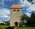
church building in Heiligengrabe, Brandenburg state, Germany  | |||||
| Upload media | |||||
| Instance of | |||||
|---|---|---|---|---|---|
| Location | Heiligengrabe, Ostprignitz-Ruppin District, Brandenburg, Germany | ||||
| Heritage designation | |||||
 | |||||
This is the category of the Brandenburger Baudenkmal (cultural heritage monument) with the ID 09170813 (Wikidata)
|
English: Church in Heiligengrabe municipality, Ostprignitz-Ruppin district, Brandenburg state, Germany
Français : Église de Heiligengrabe, arrondissement de Prignitz-de-l'Est-Ruppin, état fédéral de Brandebourg, Allemagne
Media in category "Dorfkirche (Heiligengrabe)"
The following 7 files are in this category, out of 7 total.
-
 Heiligengrabe church 2016 S.JPG 3,317 × 2,238; 2.51 MB
-
 Heiligengrabe church N 2015.JPG 2,592 × 1,944; 2.81 MB
-
 Heiligengrabe church NW 2015.JPG 2,592 × 1,944; 2.65 MB
-
 Heiligengrabe church W 2015.JPG 1,944 × 2,592; 2.9 MB
-
 Heiligengrabe Dorfkirche1.JPG 1,775 × 1,504; 2.16 MB
-
 Heiligengrabe Dorfkirche2.JPG 1,777 × 1,468; 843 KB
-
 Heiligengrabe Dorfkirche3.jpg 1,319 × 1,941; 1.04 MB


