Category:Dorfkirche (Königsberg in der Prignitz)
Jump to navigation
Jump to search
| Object location | | View all coordinates using: OpenStreetMap |
|---|
 | |||||
| Upload media | |||||
| Instance of | |||||
|---|---|---|---|---|---|
| Location | Königsberg in der Prignitz, Heiligengrabe, Ostprignitz-Ruppin District, Brandenburg, Germany | ||||
| Heritage designation | |||||
 | |||||
This is the category of the Brandenburger Baudenkmal (cultural heritage monument) with the ID 09170821 (Wikidata)
|
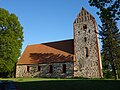
Deutsch: Die Dorfkirche in Königsberg in der Prignitz (zu Heiligengrabe), Mark Brandenburg, gehört und dient einer Gemeinde der unierten Evangelischen Kirche Berlin-Brandenburg-Schlesische Oberlausitz. Die Kirche entstand Anfang des 16. Jh.s.
English: The Village Church in Königsberg in der Prignitz (a locality of Heiligengrabe), March of Brandenburg, Germany, is owned and used by a congregation within the Evangelical Church of Berlin-Brandenburg-Silesian Upper Lusatia, a united Protestant church body of Calvinist, Lutheran and united congregations. The church was erected at the beginning of the 16th c.
Media in category "Dorfkirche (Königsberg in der Prignitz)"
The following 7 files are in this category, out of 7 total.
-
 Heiligengrabe Koenigsberg church.jpg 1,620 × 1,230; 433 KB
-
 Königsberg (Prignitz) church 2016 E.JPG 3,142 × 4,046; 4.64 MB
-
 Königsberg (Prignitz) church 2016 ESE.JPG 3,928 × 3,341; 5.52 MB
-
 Königsberg (Prignitz) church 2016 N.JPG 4,864 × 3,648; 6.72 MB
-
 Königsberg (Prignitz) church 2016 NE.JPG 4,864 × 3,648; 7.01 MB
-
 Königsberg (Prignitz) church 2016 SE.JPG 5,281 × 4,379; 10.29 MB
-
 Königsberg (Prignitz) church 2016 W.JPG 3,648 × 4,864; 6.89 MB
_church_2016_E.JPG)
_church_2016_ESE.JPG)
_church_2016_N.JPG)
_church_2016_NE.JPG)
_church_2016_SE.JPG)
_church_2016_W.JPG)