Category:Dorfkirche (Menkin)
Jump to navigation
Jump to search
| Object location | | View all coordinates using: OpenStreetMap |
|---|
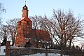
church building in Brandenburg, Germany  | |||||
| Upload media | |||||
| Instance of | |||||
|---|---|---|---|---|---|
| Location | Menkin, Brüssow, Amt Brüssow, Uckermark District, Brandenburg, Germany | ||||
| Heritage designation | |||||
 | |||||
This is the category of the Brandenburger Baudenkmal (cultural heritage monument) with the ID 09130206 (Wikidata)
|
Français : Église de Menkin, commune de Brüssow, arrondissement Uckermark, état fédéral de Brandebourg, Allemagne
Media in category "Dorfkirche (Menkin)"
The following 3 files are in this category, out of 3 total.
-
 Brüssow-Wollschow-Menkin Ortsansicht 01.jpg 4,032 × 3,024; 7.58 MB
-
 Kirche Menkin Ostseite.JPG 3,888 × 2,592; 4.63 MB
-
 Kirche Menkin Westseite.JPG 3,888 × 2,592; 5.51 MB

