Category:Dorfkirche (Pinnow an der Havel)
Jump to navigation
Jump to search
| Object location | | View all coordinates using: OpenStreetMap |
|---|
church building in Brandenburg state, Germany   | |||||
| Upload media | |||||
| Instance of | |||||
|---|---|---|---|---|---|
| Made from material | |||||
| Location | Pinnow (Hohen Neuendorf), Oberhavel District, Brandenburg, Germany | ||||
| Architectural style | |||||
| Heritage designation | |||||
 | |||||
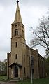
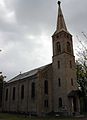
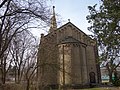
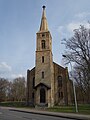
Deutsch: Die Dorfkirche in Pinnow an der Havel (zu Hohen Neuendorf), Mark Brandenburg, gehört einer Gemeinde der unierten Evangelischen Kirche Berlin-Brandenburg-Schlesische Oberlausitz. Die Kirche entstand 1861–1862 nach Plänen Friedrich August Stülers. Seit 1971 ist sie geschlossen, wird aber seit 2005 im Sommer für Radtouristen geöffnet (Radfahrerkirche).
English: The Village Church in Pinnow upon Havel (a locality of Hohen Neuendorf), March of Brandenburg, Germany, is owned by a congregation within the Evangelical Church of Berlin-Brandenburg-Silesian Upper Lusatia, a united Protestant church body of Calvinist, Lutheran and united congregations. The church was erected between 1861 and 1862 following plans of Friedrich August Stüler. It was closed in 1971, but since 2005 it is opened in summers as a station for cyclists on the Berlin-Copenhagen Cycle Route.
This is the category of the Brandenburger Baudenkmal (cultural heritage monument) with the ID 09165252 (Wikidata)
|
Media in category "Dorfkirche (Pinnow an der Havel)"
The following 11 files are in this category, out of 11 total.
-
 Dorfkirche Pinnow Hohen Neuendorf Vorderansicht.jpg 2,416 × 4,148; 4.43 MB
-
 Dorfkirche Pinnow Hohen Neuendorf.jpg 2,952 × 4,072; 6.04 MB
-
 Dorfkirche Pinnow Tür.jpg 3,000 × 4,000; 6.02 MB
-
 Dorfkirche Pinnow.jpg 3,000 × 4,000; 7.37 MB
-
 Pinnow church 2016 E.JPG 4,864 × 3,648; 8.83 MB
-
 Pinnow church 2016 NE.JPG 4,864 × 3,648; 5.2 MB
-
 Pinnow church 2016 NW.JPG 3,648 × 4,864; 4.85 MB
-
 Pinnow church 2016 S.JPG 4,864 × 3,648; 9.57 MB
-
 Pinnow church 2016 W.JPG 3,648 × 4,864; 5.25 MB
-
 Pinnow-dorfkirche.jpg 600 × 452; 89 KB
-
 Pinnow-kirche-klinke.jpg 600 × 456; 109 KB


