Category:Dorfkirche (Pinnow bei Angermünde)
Jump to navigation
Jump to search
| Object location | | View all coordinates using: OpenStreetMap |
|---|
  | |||||
| Upload media | |||||
| Instance of | |||||
|---|---|---|---|---|---|
| Location | Pinnow, Uckermark District, Brandenburg, Germany | ||||
| Heritage designation | |||||
 | |||||
This is the category of the Brandenburger Baudenkmal (cultural heritage monument) with the ID 09130521 (Wikidata)
|
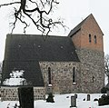
Deutsch: Die Dorfkirche in Pinnow, Mark Brandenburg, gehört einer Gemeinde der unierten Evangelischen Kirche Berlin-Brandenburg-Schlesische Oberlausitz. Die Kirche entstand in der zweiten Hälfte des 13. Jahrhunderts.
English: The Village Church in Pinnow, March of Brandenburg, Germany, is owned by a congregation within the Evangelical Church of Berlin-Brandenburg-Silesian Upper Lusatia, a united Protestant church body of Calvinist, Lutheran and united congregations. The church was erected in the 2nd half of the 13th c.
Subcategories
This category has only the following subcategory.
Media in category "Dorfkirche (Pinnow bei Angermünde)"
This category contains only the following file.
-
 Pinnow, Kirche.jpg 3,142 × 3,116; 4.15 MB