Category:Dorfkirche (Vehlefanz)
Jump to navigation
Jump to search
| Object location | | View all coordinates using: OpenStreetMap |
|---|
church building in Oberkrämer, Brandenburg state, Germany  | |||||
| Upload media | |||||
| Instance of | |||||
|---|---|---|---|---|---|
| Made from material | |||||
| Location | Vehlefanz, Oberkrämer, Oberhavel District, Brandenburg, Germany | ||||
| Heritage designation | |||||
 | |||||
This is the category of the Brandenburger Baudenkmal (cultural heritage monument) with the ID 09165140 (Wikidata)
|
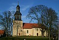
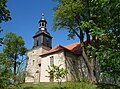
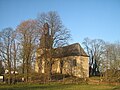
Deutsch: Die Dorfkirche in Vehlefanz, Mark Brandenburg, gehört und dient einer Gemeinde der unierten Evangelischen Kirche Berlin-Brandenburg-Schlesische Oberlausitz. Die Kirche entstand in der 2. Hälfte des 15. Jh.s und wurde zu Beginn des 18. Jh.s erweitert.
English: The Village Church in Vehlefanz, March of Brandenburg, Germany, is owned and used by a congregation within the Evangelical Church of Berlin-Brandenburg-Silesian Upper Lusatia, a united Protestant church body of Calvinist, Lutheran and united congregations. The church was erected in the 2nd half of the 15th c. and extended by the beginning of 18th c.
Media in category "Dorfkirche (Vehlefanz)"
The following 16 files are in this category, out of 16 total.
-
 20120408080DR Vehlefanz (Oberkrämer) Dorfkirche.jpg 2,412 × 1,917; 5.62 MB
-
 2018 05 Havelland Vehlefanz IMG 1940.JPG 5,812 × 3,923; 9.03 MB
-
 Kirche Vehlefanz.JPG 4,608 × 3,072; 3.52 MB
-
 Landschaft (29443427416).jpg 5,395 × 3,587; 2.93 MB
-
 Maerzmorgenvehlefanz.jpg 600 × 453; 76 KB
-
 Vehlefanz 01.01.2015 14-32-41.jpg 4,451 × 3,023; 1.75 MB
-
 Vehlefanz 01.01.2015 14-34-17.jpg 3,104 × 4,672; 1.85 MB
-
 Vehlefanz 01.01.2015 14-34-33.jpg 3,018 × 4,542; 1.53 MB
-
 Vehlefanz alte linden 3.jpg 2,448 × 3,696; 2.24 MB
-
 Vehlefanz church 2016 NE.JPG 4,760 × 3,325; 7.55 MB
-
 Vehlefanz church 2016 NNE.JPG 4,827 × 3,295; 5.9 MB
-
 Vehlefanz church 2016 S.JPG 3,511 × 3,403; 5.68 MB
-
 Vehlefanz church 2016 SE.JPG 4,784 × 3,540; 7.87 MB
-
 Vehlefanz church 2016 SSE.JPG 4,864 × 3,648; 8.32 MB
-
 Vehlefanz church.jpg 2,910 × 2,280; 1.06 MB
-
 Vehlefanz-Kirche-15-01-2008-004.jpg 1,024 × 768; 557 KB
_Dorfkirche.jpg)


.jpg)


