Category:Dorfkirche Barenthin
Jump to navigation
Jump to search
| Object location | | View all coordinates using: OpenStreetMap |
|---|
church building in Gumtow, Brandenburg state, Germany  | |||||
| Upload media | |||||
| Instance of | |||||
|---|---|---|---|---|---|
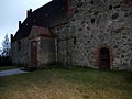
| Location | Barenthin, Gumtow, Prignitz District, Brandenburg, Germany | ||||
| Heritage designation | |||||
 | |||||
This is the category of the Brandenburger Baudenkmal (cultural heritage monument) with the ID 09160035 (Wikidata)
|
Media in category "Dorfkirche Barenthin"
The following 10 files are in this category, out of 10 total.
-
 Dorfkirche Barenthin 2017 NE.jpg 3,406 × 3,523; 6.22 MB
-
 Dorfkirche Barenthin 2017 Nordostportal.jpg 3,648 × 4,864; 5.88 MB
-
 Dorfkirche Barenthin 2017 Nordwestportal.jpg 3,648 × 4,864; 6.34 MB
-
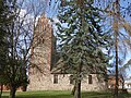 Dorfkirche Barenthin 2017 S.jpg 4,864 × 3,648; 9.62 MB
-
 Dorfkirche Barenthin 2017 SW.jpg 4,091 × 4,449; 8.91 MB
-
 Barenthin Dorfkirche 1.JPG 4,000 × 3,000; 4.47 MB
-
 Barenthin Dorfkirche 3.JPG 3,000 × 4,000; 4.47 MB
-
 Barenthin Dorfkirche 4.JPG 4,000 × 3,000; 4.46 MB
-
 Barenthin. Kanzel.png 339 × 523; 271 KB
-
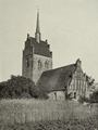 Barenthin. Kirche von Südosten.png 475 × 635; 411 KB


