Category:Dorfkirche Bartschendorf
Jump to navigation
Jump to search
| Object location | | View all coordinates using: OpenStreetMap |
|---|
church building in Brandenburg state, Germany  | |||||
| Upload media | |||||
| Instance of | |||||
|---|---|---|---|---|---|
| Location | Bartschendorf, Dreetz, Ostprignitz-Ruppin District, Brandenburg, Germany | ||||
| Heritage designation | |||||
 | |||||
This is the category of the Brandenburger Baudenkmal (cultural heritage monument) with the ID 09170517 (Wikidata)
|
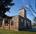
English: Ruin of Bartschendorf church, Dreetz municipality, Ostprignitz-Ruppin district, Brandenburg state, Germany
Deutsch: Ruine der Dorfkirche in Bartschendorf, Gemeinde Dreetz, Landkreis Ostprignitz-Ruppin, Land Brandenburg, Deutschland.
Français : Ruine de l'église de Bartschendorf, commune de Dreetz, arrondissement Prignitz-de-l'Est-Ruppin, état fédéral de Brandebourg, Allemagne
Media in category "Dorfkirche Bartschendorf"
The following 11 files are in this category, out of 11 total.
-
 Dorfkirche Bartschendorf 2016 NE.jpg 4,663 × 4,476; 8.03 MB
-
 Dorfkirche Bartschendorf 2016 NNE.jpg 4,864 × 3,648; 6.25 MB
-
 Dorfkirche Bartschendorf 2016 Portal N.jpg 3,648 × 4,864; 5.97 MB
-
 Dorfkirche Bartschendorf 2016 Portal W.jpg 3,582 × 4,816; 7.42 MB
-
 Dorfkirche Bartschendorf 2016 SE.jpg 4,556 × 4,518; 8.35 MB
-
 Dorfkirche Bartschendorf 2016 SW.jpg 4,864 × 3,648; 5.4 MB
-
 Dorfkirche Bartschendorf 2016 W.jpg 4,864 × 3,648; 5.33 MB
-
 Dorfkirche Bartschendorf 2016 WNW.jpg 3,648 × 4,864; 7.54 MB
-
 Lausitz Luftsport- & Techniktage 2013-Hinflug by-RaBoe 0796.jpg 2,600 × 1,727; 1.17 MB
-
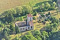 Lausitz Luftsport- & Techniktage 2013-Hinflug by-RaBoe 0797.jpg 2,600 × 1,727; 989 KB
-
 Lausitz Luftsport- & Techniktage 2013-Hinflug by-RaBoe 0799.jpg 2,600 × 1,727; 817 KB


