Category:Dorfkirche Bergfelde
Jump to navigation
Jump to search
| Object location | | View all coordinates using: OpenStreetMap |
|---|
church building in Brandenburg state, Germany  | |||||
| Upload media | |||||
| Instance of | |||||
|---|---|---|---|---|---|
| Location | Bergfelde, Hohen Neuendorf, Oberhavel District, Brandenburg, Germany | ||||
| Heritage designation | |||||
 | |||||
English: Pictures of the church in Bergfelde , Hohen Neuendorf municipality , Oberhavel district, Brandenburg state, Germany.
Deutsch: Ansichten der Kirche in Bergfelde , Stadt Hohen Neuendorf , Landkreis Oberhavel , Land Brandenburg, Deutschland.
Français : Photos de l'église à Bergfelde , ville de Hohen Neuendorf , arrondissement de Oberhavel , état fédéral de Brandebourg, Allemagne
Español: Vistas de la iglesia en Bergfelde , ciudad de Hohen Neuendorf , distrito de Oberhavel , estado federado de Brandeburgo, Alemania
This is the category of the Brandenburger Baudenkmal (cultural heritage monument) with the ID 09165638 (Wikidata)
|
Address:
Herthastraße 64, Bergfelde, 16562 Hohen Neuendorf
Subcategories
This category has only the following subcategory.
I
Pages in category "Dorfkirche Bergfelde"
This category contains only the following page.
Media in category "Dorfkirche Bergfelde"
The following 10 files are in this category, out of 10 total.
-
 Bergfelde church.jpg 2,080 × 2,480; 730 KB
-
 Dorfkirche Bergfelde 2018 E.jpg 4,229 × 2,669; 5.83 MB
-
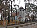 Dorfkirche Bergfelde 2018 N.jpg 4,848 × 3,626; 8.32 MB
-
 Dorfkirche Bergfelde 2018 NW.jpg 3,446 × 4,718; 7.78 MB
-
 Dorfkirche Bergfelde 2018 S.jpg 4,864 × 3,648; 8.44 MB
-
 Dorfkirche Bergfelde 2018 SW.jpg 4,856 × 3,638; 8.06 MB
-
 Dorfkirche Bergfelde 2018 W.jpg 4,756 × 3,502; 6.98 MB
-
 Dorfkirche Bergfelde 2018 Westportal.jpg 3,412 × 4,054; 6.3 MB
-
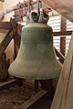 Dorfkirche Bergfelde Glocke.jpg 3,456 × 5,184; 3.8 MB
-
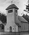 Kirche Bergfelde 1936.jpg 736 × 882; 653 KB


