Category:Dorfkirche Bertikow
Jump to navigation
Jump to search
| Object location | | View all coordinates using: OpenStreetMap |
|---|
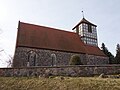
church building in Bertikow, Brandenburg state, Germany  | |||||
| Upload media | |||||
| Instance of | |||||
|---|---|---|---|---|---|
| Location | Bertikow, Uckerfelde, Uckermark District, Brandenburg, Germany | ||||
| Heritage designation | |||||
 | |||||
This is the category of the Brandenburger Baudenkmal (cultural heritage monument) with the ID 09130362 (Wikidata)
|
Deutsch: Ansichten der Kirche in Bertikow , Gemeinde Uckerfelde , Landkreis Uckermark , Land Brandenburg, Deutschland.
English: Pictures of the church in Bertikow , Uckerfelde municipality , Uckermark district, Brandenburg state, Germany
Français : Photos de l'église à Bertikow , commune de Uckerfelde , arrondissement de Uckermark , état fédéral de Brandebourg, Allemagne
Pages in category "Dorfkirche Bertikow"
This category contains only the following page.
Media in category "Dorfkirche Bertikow"
The following 11 files are in this category, out of 11 total.
-
 Bertikow 08 17 02 jiw.jpg 1,920 × 1,280; 832 KB
-
 Bertikower Kirche - geo.hlipp.de - 29048.jpg 640 × 480; 139 KB
-
 Dorfkirche Bertikow 2018 E.jpg 3,648 × 4,864; 8.2 MB
-
 Dorfkirche Bertikow 2018 N.jpg 4,864 × 3,648; 7.49 MB
-
 Dorfkirche Bertikow 2018 NNE.jpg 4,864 × 3,648; 6.36 MB
-
 Dorfkirche Bertikow 2018 NW.jpg 4,248 × 4,315; 6.72 MB
-
 Dorfkirche Bertikow 2018 S.jpg 4,864 × 3,648; 6.09 MB
-
 Dorfkirche Bertikow 2018 SE.jpg 4,880 × 3,986; 9.8 MB
-
 Dorfkirche Bertikow 2018 SSW.jpg 4,864 × 3,648; 5.74 MB
-
 Dorfkirche Bertikow 2018 vermauertes Nordportal.jpg 4,864 × 3,648; 9.67 MB
-
 Dorfkirche Bertikow 2018 Westportal.jpg 4,810 × 3,576; 7.94 MB


