Category:Dorfkirche Bollensdorf
Jump to navigation
Jump to search
| Object location | | View all coordinates using: OpenStreetMap |
|---|
church building in Brandenburg  | |||||
| Upload media | |||||
| Instance of | |||||
|---|---|---|---|---|---|
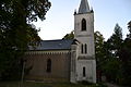
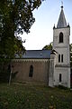
| Location | Neuenhagen bei Berlin, Märkisch-Oderland District, Brandenburg, Germany | ||||
| Architectural style | |||||
| Heritage designation | |||||
| Inception |
| ||||
 | |||||
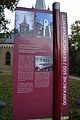
This is the category of the Brandenburger Baudenkmal (cultural heritage monument) with the ID 09180567 (Wikidata)
|
Deutsch: Bilder der Kirche in Bollensdorf, Gemeinde Neuenhagen bei Berlin, Landkreis Märkisch-Oderland, Land Brandenburg, Deutschland.
English: Pictures of the church in Bollensdorf, Neuenhagen bei Berlin municipality, Märkisch-Oderland district, Brandenburg state, Germany
Français : Photos de l'église à Bollensdorf, commune de Neuenhagen bei Berlin, arrondissement de Märkisch-Oderland, état fédéral de Brandebourg, Allemagne
Media in category "Dorfkirche Bollensdorf"
The following 18 files are in this category, out of 18 total.
-
 Dorfkirche Bollensdorf 1.jpg 4,608 × 3,072; 8.57 MB
-
 Dorfkirche Bollensdorf 2.JPG 4,608 × 3,072; 7.79 MB
-
 Dorfkirche Bollensdorf 3.JPG 3,072 × 4,608; 6.64 MB
-
 Dorfkirche Bollensdorf 30.JPG 3,072 × 4,608; 5.57 MB
-
 Dorfkirche Bollensdorf 31.JPG 4,608 × 3,072; 6.54 MB
-
 Dorfkirche Bollensdorf 32.JPG 4,608 × 3,072; 7.74 MB
-
 Dorfkirche Bollensdorf 33.JPG 3,072 × 4,608; 5.93 MB
-
 Dorfkirche Bollensdorf 34.JPG 3,072 × 4,608; 6.11 MB
-
 Dorfkirche Bollensdorf 35.JPG 3,072 × 4,608; 6.02 MB
-
 Dorfkirche Bollensdorf 36.JPG 3,072 × 4,608; 5.94 MB
-
 Dorfkirche Bollensdorf 37.JPG 4,608 × 3,072; 6.37 MB
-
 Dorfkirche Bollensdorf 38.JPG 4,608 × 3,072; 7.37 MB
-
 Dorfkirche Bollensdorf 39.JPG 3,072 × 4,608; 7.17 MB
-
 Dorfkirche Bollensdorf 4.JPG 4,608 × 3,072; 7.21 MB
-
 Dorfkirche Bollensdorf 40.JPG 4,608 × 3,072; 6.33 MB
-
 Dorfkirche Bollensdorf 41.JPG 3,072 × 4,608; 7.92 MB
-
 Dorfkirche Bollensdorf 5.JPG 4,608 × 3,072; 5.97 MB
-
 Dorfkirche Bollensdorf 8.JPG 3,072 × 4,608; 6.69 MB


