Category:Dorfkirche Dabergotz
Jump to navigation
Jump to search
| Object location | | View all coordinates using: OpenStreetMap |
|---|
This is the category of the Brandenburger Baudenkmal (cultural heritage monument) with the ID 09170247 (Wikidata)
|
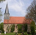
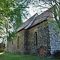
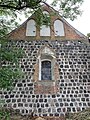
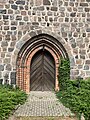
Deutsch: Ansichten der Kirche in Dabergotz , Gemeinde Dabergotz , Landkreis Ostprignitz-Ruppin , Land Brandenburg, Deutschland.
English: Pictures of the church in Dabergotz , Dabergotz municipality , Ostprignitz-Ruppin district, Brandenburg state, Germany.
Français : Photos de l'église à Dabergotz , commune de Dabergotz , arrondissement de Ostprignitz-Ruppin , état fédéral de Brandebourg, Allemagne
Español: Vistas de la iglesia en Dabergotz , municipio de Dabergotz , distrito de Ostprignitz-Ruppin , estado federado de Brandeburgo, Alemania
church building in Brandenburg state, Germany  | |||||
| Upload media | |||||
| Instance of | |||||
|---|---|---|---|---|---|
| Location | Dabergotz, Ostprignitz-Ruppin District, Brandenburg, Germany | ||||
| Heritage designation | |||||
 | |||||
Pages in category "Dorfkirche Dabergotz"
This category contains only the following page.
Media in category "Dorfkirche Dabergotz"
The following 29 files are in this category, out of 29 total.
-
 Dabergotz church.jpg 1,380 × 1,320; 301 KB
-
 Dorfkirche Dabergotz 2019 Bank an der Südmauer.jpg 4,864 × 3,648; 7.38 MB
-
 Dorfkirche Dabergotz 2019 Chorportal.jpg 3,648 × 4,864; 7.67 MB
-
 Dorfkirche Dabergotz 2019 Friedhofstor.jpg 3,648 × 4,864; 6.9 MB
-
 Dorfkirche Dabergotz 2019 NE.jpg 4,864 × 3,648; 7.65 MB
-
 Dorfkirche Dabergotz 2019 Nordportal vermauert.jpg 4,864 × 3,648; 7.26 MB
-
 Dorfkirche Dabergotz 2019 NW.jpg 4,105 × 4,577; 7.82 MB
-
 Dorfkirche Dabergotz 2019 S.jpg 4,547 × 3,678; 7.46 MB
-
 Dorfkirche Dabergotz 2019 SE.jpg 4,116 × 4,116; 7.09 MB
-
 Dorfkirche Dabergotz 2019 Südportal vermauert.jpg 3,648 × 4,864; 6.39 MB
-
 Dorfkirche Dabergotz 2019 Turm NW.jpg 3,648 × 4,864; 5.05 MB
-
 Dorfkirche Dabergotz 2019 Turmhaube.jpg 3,648 × 4,864; 3.88 MB
-
 Dorfkirche Dabergotz 2019 W.jpg 3,648 × 4,864; 5.05 MB
-
 Dorfkirche Dabergotz 2019 Westportal.jpg 3,608 × 4,834; 7.85 MB
-
 Dorfkirche Dabergotz Chor Nordansicht.jpg 4,032 × 3,024; 5.09 MB
-
 Dorfkirche Dabergotz Chor Südansicht.jpg 4,032 × 3,024; 5.03 MB
-
 Dorfkirche Dabergotz Denkmal Weltkriege.jpg 4,032 × 3,024; 5.49 MB
-
 Dorfkirche Dabergotz Kirchenschiff Nordwestansicht.jpg 4,032 × 3,024; 5.33 MB
-
 Dorfkirche Dabergotz Kirchenschiff Südansicht.jpg 4,032 × 3,024; 5.03 MB
-
 Dorfkirche Dabergotz Kirchenschiff Südwestansicht 2.jpg 3,024 × 4,032; 5 MB
-
 Dorfkirche Dabergotz Kirchenschoff Nordansicht.jpg 4,032 × 3,024; 5.18 MB
-
 Dorfkirche Dabergotz Nordostansicht.jpg 4,032 × 3,024; 4.22 MB
-
 Dorfkirche Dabergotz Nordwestansicht.jpg 3,024 × 4,032; 3.03 MB
-
 Dorfkirche Dabergotz Ostansicht.jpg 3,024 × 4,032; 4.68 MB
-
 Dorfkirche Dabergotz Südostansicht.jpg 4,032 × 3,024; 5.31 MB
-
 Dorfkirche Dabergotz Westportal.jpg 3,024 × 4,032; 5.14 MB
-
 Dorfkirche Dabergotz Westturm Südansicht.jpg 3,024 × 4,032; 4.88 MB
-
 Dorfkirche Dabergotz Westturm Südwestansicht.jpg 3,024 × 4,032; 3.16 MB
-
 Dorfkirche Dabergotz Westturm Westansicht.jpg 3,024 × 4,032; 3.57 MB


