Category:Dorfkirche Dreetz (Brandenburg)
Jump to navigation
Jump to search
| Object location | | View all coordinates using: OpenStreetMap |
|---|
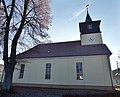
_2016_SW.jpg) | |||||
| Upload media | |||||
| Instance of | |||||
|---|---|---|---|---|---|
| Location | Dreetz, Ostprignitz-Ruppin District, Brandenburg, Germany | ||||
| Heritage designation | |||||
 | |||||
This is the category of the Brandenburger Baudenkmal (cultural heritage monument) with the ID 09170534 (Wikidata)
|
Français : Église de Dreetz, arrondissement Prignitz-de-l'Est-Ruppin, état fédéral de Brandebourg, Allemagne
Media in category "Dorfkirche Dreetz (Brandenburg)"
The following 7 files are in this category, out of 7 total.
-
 Dorfkirche Dreetz (Brandenburg) 2016 N.jpg 5,938 × 4,810; 10.55 MB
-
 Dorfkirche Dreetz (Brandenburg) 2016 NE.jpg 4,295 × 4,041; 7.03 MB
-
 Dorfkirche Dreetz (Brandenburg) 2016 Portal E.jpg 3,648 × 4,864; 5.35 MB
-
 Dorfkirche Dreetz (Brandenburg) 2016 Portal W.jpg 3,648 × 4,864; 3.89 MB
-
 Dorfkirche Dreetz (Brandenburg) 2016 S.jpg 4,864 × 3,648; 7.95 MB
-
 Dorfkirche Dreetz (Brandenburg) 2016 SE.jpg 4,864 × 3,648; 6.38 MB
-
 Dorfkirche Dreetz (Brandenburg) 2016 SW.jpg 4,220 × 4,442; 9.02 MB
_2016_N.jpg)
_2016_NE.jpg)
_2016_Portal_E.jpg)
_2016_Portal_W.jpg)
_2016_S.jpg)
_2016_SE.jpg)