Category:Dorfkirche Dubro
Jump to navigation
Jump to search
| Object location | | View all coordinates using: OpenStreetMap |
|---|
church building in Elbe-Elster district, Brandenburg state, Germany  | |||||
| Upload media | |||||
| Instance of | |||||
|---|---|---|---|---|---|
| Dedicated to | |||||
| Location | Dubro, Schönewalde, Elbe-Elster District, Brandenburg, Germany | ||||
| Street address |
| ||||
| Heritage designation | |||||
| Inception |
| ||||
| Religion or worldview | |||||
 | |||||
This is the category of the Brandenburger Baudenkmal (cultural heritage monument) with the ID 09135143 (Wikidata)
|
Address:
An den Teichen, 04916 Schönewalde
English: Pictures of the church in Dubro, Schönewalde municipality, Elbe-Elster district, Brandenburg state, Germany.
Deutsch: Ansichten der Kirche in Dubro, Gemeinde Schönewalde, Landkreis Elbe-Elster, Land Brandenburg, Deutschland.
Français : Photos de l'église à Dubro, commune de Schönewalde, arrondissement de Elbe-Elster, état fédéral de Brandebourg, Allemagne
Español: Vistas de la iglesia en Dubro, municipio de Schönewalde, distrito de Elbe-Elster, estado federado de Brandeburgo, Alemania
Pages in category "Dorfkirche Dubro"
This category contains only the following page.
Media in category "Dorfkirche Dubro"
The following 13 files are in this category, out of 13 total.
-
 Dorfkirche Dubro 2021 E.jpg 3,598 × 4,826; 5.08 MB
-
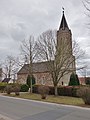
 Dorfkirche Dubro 2021 ENE.jpg 3,538 × 4,782; 5.22 MB
-
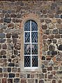 Dorfkirche Dubro 2021 Fenster.jpg 3,598 × 4,826; 7.55 MB
-
 Dorfkirche Dubro 2021 N.jpg 3,070 × 2,304; 3.08 MB
-
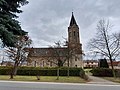
 Dorfkirche Dubro 2021 NNW.jpg 3,648 × 4,864; 7.14 MB
-
 Dorfkirche Dubro 2021 NW.jpg 3,456 × 4,608; 5.26 MB
-
 Dorfkirche Dubro 2021 SE.jpg 4,554 × 4,750; 7.28 MB
-
 Dorfkirche Dubro 2021 SW.jpg 3,648 × 4,864; 7.55 MB
-
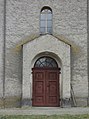
 Dorfkirche Dubro 2021 Südportal.jpg 3,598 × 4,826; 7.54 MB
-
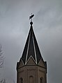 Dorfkirche Dubro 2021 Turmhaube.jpg 3,538 × 4,782; 4.09 MB
-
 Dorfkirche Dubro 2021 vermauertes Südportal.jpg 4,864 × 3,648; 6.45 MB
-
 Dorfkirche Dubro 2021 Westportal.jpg 3,598 × 4,826; 7.28 MB
-
 Dorfkirche Dubro 2021 Winterkirche.jpg 4,782 × 3,538; 4.12 MB


