Category:Dorfkirche Fohrde
Jump to navigation
Jump to search
| Object location | | View all coordinates using: OpenStreetMap |
|---|
church building in Havelsee, Germany  | |||||
| Upload media | |||||
| Instance of | |||||
|---|---|---|---|---|---|
| Location | Havelsee, Amt Beetzsee, Potsdam-Mittelmark District, Brandenburg, Germany | ||||
| Architectural style | |||||
| Heritage designation | |||||
 | |||||
Media in category "Dorfkirche Fohrde"
The following 8 files are in this category, out of 8 total.
-
 Altar fohrde.JPG 1,944 × 2,592; 1.41 MB
-
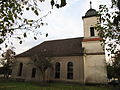 Kirche fohrde.JPG 2,592 × 1,944; 1.5 MB
-
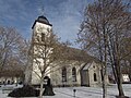 Kirchefohrde.JPG 2,816 × 2,112; 3.39 MB
-
 Kirchefohrdenordost.JPG 2,592 × 1,944; 1.71 MB
-
 Kirchefohrdesuedost.JPG 2,592 × 1,944; 1.64 MB
-
 Kirchturmfohrde.JPG 1,944 × 2,592; 1.82 MB
-
 Kirchturmspitzefohrde.JPG 1,944 × 2,592; 915 KB
-
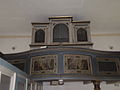 Orgel fohrde.JPG 2,592 × 1,944; 1.18 MB


