Category:Dorfkirche Groß Rietz
Jump to navigation
Jump to search
| Object location | | View all coordinates using: OpenStreetMap |
|---|
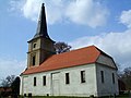
church building in Oder-Spree district, Brandenburg state, Germany  | |||||
| Upload media | |||||
| Instance of | |||||
|---|---|---|---|---|---|
| Location | Groß Rietz, Rietz-Neuendorf, Oder-Spree District, Brandenburg, Germany | ||||
| Heritage designation | |||||
 | |||||
This is the category of the Brandenburger Baudenkmal (cultural heritage monument) with the ID 09115241 (Wikidata)
|
Media in category "Dorfkirche Groß Rietz"
The following 15 files are in this category, out of 15 total.
-
 Dorfkirche Groß Rietz Friedhof.jpg 4,608 × 3,456; 6.41 MB
-
 Dorfkirche Groß Rietz Gefallene Weltkrieg.jpg 3,456 × 4,608; 5.78 MB
-
 Dorfkirche Groß Rietz Nordansicht Chor.jpg 4,608 × 3,456; 4.32 MB
-
 Dorfkirche Groß Rietz Nordansicht Kirchenschiff.jpg 4,608 × 3,456; 5.65 MB
-
 Dorfkirche Groß Rietz Nordansicht Nordportal.jpg 4,608 × 3,456; 5.48 MB
-
 Dorfkirche Groß Rietz Nordansicht Westturm.jpg 3,456 × 4,608; 5.63 MB
-
 Dorfkirche Groß Rietz Nordostansicht.jpg 3,456 × 4,608; 3.96 MB
-
 Dorfkirche Groß Rietz Nordportal Westturm.jpg 4,608 × 3,456; 4.27 MB
-
 Dorfkirche Groß Rietz Ostansicht.jpg 4,608 × 3,456; 4.63 MB
-
 Dorfkirche Groß Rietz Südansicht Kirchenschiff.jpg 4,608 × 3,456; 5.21 MB
-
 Dorfkirche Groß Rietz Südansicht Kirchturm.jpg 3,456 × 4,608; 4.73 MB
-
 Dorfkirche Groß Rietz Südostansicht.jpg 4,608 × 3,456; 5.02 MB
-
 Dorfkirche Groß Rietz Südwestansicht.jpg 3,456 × 4,608; 4.88 MB
-
 Dorfkirche Groß Rietz Westansicht.jpg 3,456 × 4,608; 5.16 MB
-
 Kirche Gross Rietz.jpg 4,320 × 3,240; 9.42 MB


