Category:Dorfkirche Gülpe
Jump to navigation
Jump to search
| Object location | | View all coordinates using: OpenStreetMap |
|---|
.jpg) | |||||
| Upload media | |||||
| Instance of | |||||
|---|---|---|---|---|---|
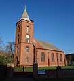
| Location | Gülpe, Havelaue, Havelland District, Brandenburg, Germany | ||||
| Heritage designation | |||||
 | |||||
This is the category of the Brandenburger Baudenkmal (cultural heritage monument) with the ID 09150673 (Wikidata)
|
Deutsch: Dorfkirche in Gülpe, Gemeinde Havelaue, Landkreis Havelland, Land Brandenburg, Deutschland.
Français : Église de Gülpe, commune de Havelaue, arrondissement Pays de la Havel, état fédéral de Brandebourg, Allemagne
Media in category "Dorfkirche Gülpe"
The following 6 files are in this category, out of 6 total.
-
 Dorfkirche Gülpe 2016 NE.jpg 3,576 × 3,961; 5.9 MB
-
 Dorfkirche Gülpe 2016 Portal W.jpg 3,648 × 4,864; 8.52 MB
-
 Dorfkirche Gülpe 2016 S (2).jpg 4,242 × 3,336; 6.95 MB
-
 Dorfkirche Gülpe 2016 S.jpg 4,864 × 3,648; 5.37 MB
-
 Dorfkirche Gülpe 2016 SE.jpg 4,295 × 4,633; 8.24 MB
-
 Dorfkirche Gülpe 2016 SW.jpg 3,950 × 4,330; 6.5 MB


