Category:Dorfkirche Haßleben (Boitzenburger Land)
Jump to navigation
Jump to search
| Object location | | View all coordinates using: OpenStreetMap |
|---|
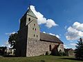
church building in Brandenburg state, Germany  | |||||
| Upload media | |||||
| Instance of | |||||
|---|---|---|---|---|---|
| Location | Boitzenburger Land, Uckermark District, Brandenburg, Germany | ||||
| Heritage designation | |||||
 | |||||
English: Church in Haßleben, Boitzenburger Land municipality, Uckermark district, Brandenburg state, Germany
Deutsch: Kirche in Haßleben, Gemeinde Boitzenburger Land, Landkreis Uckermark, Land Brandenburg, Deutschland.
Français : Église de Haßleben, commune de Boitzenburger Land, arrondissement Uckermark, état fédéral de Brandebourg, Allemagne
This is the category of the Brandenburger Baudenkmal (cultural heritage monument) with the ID 09130500 (Wikidata)
|
Media in category "Dorfkirche Haßleben (Boitzenburger Land)"
The following 14 files are in this category, out of 14 total.
-
 Boitzenburger Land Haßleben Dorfkirche Kirchenschiff Buntglasfenster.jpg 2,592 × 1,944; 2.47 MB
-
 Boitzenburger Land Haßleben Dorfkirche Kirchenschiff Südansicht.jpg 2,592 × 1,944; 3.33 MB
-
 Boitzenburger Land Haßleben Dorfkirche Nordansicht.jpg 2,592 × 1,944; 3.28 MB
-
 Boitzenburger Land Haßleben Dorfkirche Nordostansicht.jpg 2,592 × 1,944; 2.61 MB
-
 Boitzenburger Land Haßleben Dorfkirche Ostansicht.jpg 2,592 × 1,944; 2.53 MB
-
 Boitzenburger Land Haßleben Dorfkirche Südansicht.jpg 2,592 × 1,944; 2.83 MB
-
 Boitzenburger Land Haßleben Dorfkirche Südostansicht.jpg 2,592 × 1,944; 2.86 MB
-
 Boitzenburger Land Haßleben Dorfkirche Südvorhalle.jpg 2,592 × 1,944; 3.5 MB
-
 Boitzenburger Land Haßleben Dorfkirche Südwestansicht.jpg 2,592 × 1,944; 2.25 MB
-
 Boitzenburger Land Haßleben Dorfkirche Westportal.jpg 2,592 × 1,944; 3.18 MB
-
 Boitzenburger Land Haßleben Dorfkirche Westturm Erdgeschoss.jpg 2,592 × 1,944; 2.7 MB
-
 Boitzenburger Land Haßleben Dorfkirche Westturm Nordansicht.jpg 1,944 × 2,592; 1.74 MB
-
 Boitzenburger Land Haßleben Dorfkirche Westturm Westansicht.jpg 1,944 × 2,592; 1.7 MB
-
 Haßleben, Dorfkirche.JPG 2,048 × 1,301; 698 KB


