Category:Dorfkirche Ketzür
Jump to navigation
Jump to search
| Object location | | View all coordinates using: OpenStreetMap |
|---|
This is the category of the Brandenburger Baudenkmal (cultural heritage monument) with the ID 09190228 (Wikidata)
|
 | |||||
| Upload media | |||||
| Instance of | |||||
|---|---|---|---|---|---|
| Location | Beetzseeheide, Amt Beetzsee, Potsdam-Mittelmark District, Brandenburg, Germany | ||||
| Architectural style | |||||
| Heritage designation | |||||
 | |||||
Subcategories
This category has only the following subcategory.
L
Media in category "Dorfkirche Ketzür"
The following 27 files are in this category, out of 27 total.
-
 Dorfkirche Ketzür.jpg 2,112 × 2,816; 2.07 MB
-
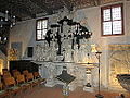 Epitaph ketzür.JPG 2,816 × 2,112; 951 KB
-
 Gortz kirche baudenkmal - 1.jpg 2,336 × 4,160; 2.93 MB
-
 Gortz kirche baudenkmal - 2.jpg 2,336 × 4,160; 2.43 MB
-
 Gortz kirche baudenkmal - 3.jpg 2,336 × 4,160; 3.17 MB
-
 Gortz kirche baudenkmal - 5.jpg 2,336 × 4,160; 3.01 MB
-
 Gortz kirche baudenkmal - 6.jpg 2,336 × 4,160; 3.62 MB
-
 Gortz kirche baudenkmal - 7.jpg 2,336 × 4,160; 4.1 MB
-
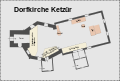 Grundriss der kirche ketzür.svg 2,485 × 1,685; 23 KB
-
 Ketzür Kirche 1.JPG 1,932 × 2,376; 3.73 MB
-
 Ketzür.jpg 1,480 × 1,859; 297 KB
-
 Kirche Ketzuer.JPG 1,808 × 2,000; 2.83 MB
-
 Kircheketzür norden 1.JPG 2,592 × 1,944; 1.64 MB
-
 Kircheketzür ostgiebel.JPG 2,592 × 1,944; 1.25 MB
-
 Kircheketzür schild.JPG 1,944 × 2,592; 1.39 MB
-
 Kircheketzür süden 2.JPG 2,592 × 1,944; 1.63 MB
-
 Kircheketzür süden 3.JPG 2,592 × 1,944; 1.91 MB
-
 Kircheketzür süden.JPG 2,592 × 1,944; 1.64 MB
-
 Kircheketzür turm und westportal frontal.JPG 1,944 × 2,592; 1.56 MB
-
 Kircheketzür westportal2.JPG 1,944 × 2,592; 1.73 MB
-
 Kircheketzür1.JPG 2,592 × 1,944; 2.21 MB
-
 Kircheketzür1x.JPG 2,592 × 1,944; 1.84 MB
-
 Luftbild Dorfkirche Ketzür.jpg 4,000 × 3,000; 4.46 MB
-
 Luftbild Kirche Ketzür.jpg 4,000 × 3,000; 5.3 MB
-
 Luftbild Kirche Ketzür2.jpg 4,000 × 3,000; 4.78 MB
-
 Patronatsloge ketzür.JPG 2,816 × 2,112; 1.57 MB
-
 Renaissancegiebel kirche ketzür.JPG 2,816 × 2,112; 924 KB


