Category:Dorfkirche Kletzke
Jump to navigation
Jump to search
| Object location | | View all coordinates using: OpenStreetMap |
|---|
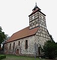
church building in Prignitz district Brandenburg state, Germany  | |||||
| Upload media | |||||
| Instance of | |||||
|---|---|---|---|---|---|
| Location | Kletzke, Plattenburg, Prignitz District, Brandenburg, Germany | ||||
| Heritage designation | |||||
 | |||||
This is the category of the Brandenburger Baudenkmal (cultural heritage monument) with the ID 09160197 (Wikidata)
|
Deutsch: Kirche in Kletzke, Gemeinde Plattenburg, Landkreis Prignitz, Land Brandenburg, Deutschland.
Français : Église de Kletzke, commune de Plattenburg, arrondissement Prignitz, état fédéral de Brandebourg, Allemagne
Media in category "Dorfkirche Kletzke"
The following 19 files are in this category, out of 19 total.
-
 Kletzke church 2016 NW.jpg 4,498 × 4,709; 5.6 MB
-
 Kletzke church 2016 portal W.jpg 4,864 × 3,648; 6.05 MB
-
 Kletzke church 2016 SW.jpg 3,648 × 4,864; 3.14 MB
-
 Kletzke477Kirche v N.JPG 4,000 × 3,000; 5.18 MB
-
 Kletzke478Kirche Nordportale.JPG 4,000 × 3,000; 4.56 MB
-
 Kletzke480spätgot. Nordportal.JPG 3,000 × 4,000; 4.66 MB
-
 Kletzke481Kirche v W.JPG 3,000 × 4,000; 4.59 MB
-
 Kletzke482rechtes Westportal.JPG 3,000 × 4,000; 4.47 MB
-
 Kletzke483linkes Westportal.JPG 3,000 × 4,000; 5.01 MB
-
 Kletzke484Südseite.JPG 4,000 × 3,000; 4.65 MB
-
 Kletzke485Apsis v S (str, vert190).JPG 3,999 × 3,175; 10.96 MB
-
 Kletzke487Apsis v S (str, vert190).JPG 2,992 × 4,222; 10.85 MB
-
 Kletzke489Pfarrhaus Leerstand.JPG 4,000 × 3,000; 4.94 MB
-
 Kletzke490Kirche + Pfarrhof.JPG 4,000 × 3,000; 5.73 MB
-
 Kletzke492Apsis v N.JPG 4,000 × 3,000; 7.59 MB
-
 Kletzke493Apsis + Schiff v NO.JPG 4,000 × 3,000; 5.05 MB
-
 Kletzke494KIrche kleines Nordportal.JPG 3,000 × 4,000; 4.73 MB
-
 Kletzke495KIrche Nordwand Ost.JPG 3,000 × 4,000; 4.76 MB
-
 Prignitz 07-13 img12 Plattenburg Kirche in Kletzke.jpg 2,960 × 3,624; 3.88 MB


.JPG)
.JPG)


