Category:Dorfkirche Neu Schadow
Jump to navigation
Jump to search
| Object location | | View all coordinates using: OpenStreetMap |
|---|
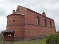
listed hall church in Neu Schadow, Märkische Heide, Brandenburg state of Germany  Dorfkirche Neu Schadow, Nordwestansicht  Dorfkirche Neu Schadow, Westportal | |||||
| Upload media | |||||
| Instance of | |||||
|---|---|---|---|---|---|
| Made from material | |||||
| Location | Neu Schadow, Märkische Heide, Dahme-Spreewald District, Brandenburg, Germany | ||||
| Street address |
| ||||
| Architectural style | |||||
| Owned by | |||||
| Occupant | |||||
| Heritage designation | |||||
| Inception |
| ||||
| Significant event |
| ||||
 | |||||
This is the category of the Brandenburger Baudenkmal (cultural heritage monument) with the ID 09140247 (Wikidata)
|
Media in category "Dorfkirche Neu Schadow"
The following 5 files are in this category, out of 5 total.
-
 Neu Schadow Dorfkirche Nordwestansicht.jpg 2,592 × 1,944; 871 KB
-
 Neu Schadow Dorfkirche Ostansicht.jpg 2,592 × 1,944; 2.19 MB
-
 Neu Schadow Dorfkirche Südansicht.jpg 2,592 × 1,944; 2.54 MB
-
 Neu Schadow Dorfkirche Südostansicht.jpg 2,592 × 1,944; 2.47 MB
-
 Neu Schadow Dorfkirche Westportal.jpg 2,592 × 1,944; 2.84 MB


