Category:Dorfkirche Neuentempel
Jump to navigation
Jump to search
| Object location | | View all coordinates using: OpenStreetMap |
|---|
 | |||||
| Upload media | |||||
| Instance of | |||||
|---|---|---|---|---|---|
| Location | Neuentempel, Vierlinden, Märkisch-Oderland District, Brandenburg, Germany | ||||
| Heritage designation | |||||
 | |||||
This is the category of the Brandenburger Baudenkmal (cultural heritage monument) with the ID 09180415 (Wikidata)
|
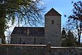
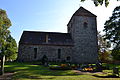
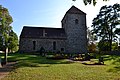
Deutsch: Bilder der Kirche in Neuentempel, Gemeinde Vierlinden, Landkreis Märkisch-Oderland, Land Brandenburg, Deutschland.
English: Pictures of the church in Neuentempel, Vierlinden municipality, Märkisch-Oderland district, Brandenburg state, Germany
Français : Photos de l'église à Neuentempel, commune de Vierlinden, arrondissement de Märkisch-Oderland, état fédéral de Brandebourg, Allemagne
Media in category "Dorfkirche Neuentempel"
The following 9 files are in this category, out of 9 total.
-
 DEU-BB-MOL-Vierlinden-Neuentempel - Dorfkirche (2).jpg 4,608 × 3,072; 10.02 MB
-
 DEU-BB-MOL-Vierlinden-Neuentempel - Dorfkirche (3).jpg 4,508 × 2,928; 8.07 MB
-
 DEU-BB-MOL-Vierlinden-Neuentempel - Dorfkirche (4).jpg 4,426 × 2,959; 8.73 MB
-
 DEU-BB-MOL-Vierlinden-Neuentempel - Dorfkirche (5).jpg 4,508 × 2,872; 8.7 MB
-
 Dorfkirche Neuentempel 1.JPG 4,608 × 3,072; 7.85 MB
-
 Dorfkirche Neuentempel 2.JPG 4,608 × 3,072; 6.58 MB
-
 Dorfkirche Neuentempel 3.JPG 4,608 × 3,072; 8.01 MB
-
 Feuerwehr Neuentempel.JPG 4,608 × 3,072; 8.09 MB
-
 Neuentempel, Kirche.jpg 2,691 × 2,448; 2.04 MB
.jpg)
.jpg)
.jpg)
.jpg)


