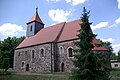
Category:Dorfkirche Neuheim
Jump to navigation
Jump to search
| Object location | | View all coordinates using: OpenStreetMap |
|---|
This is the category of the Brandenburger Baudenkmal (cultural heritage monument) with the ID 09105146 (Wikidata)
|
church building in Jüterbog, Germany  | |||||
| Upload media | |||||
| Instance of | |||||
|---|---|---|---|---|---|
| Location | Jüterbog, Teltow-Fläming District, Brandenburg, Germany | ||||
| Heritage designation | |||||
 | |||||
Media in category "Dorfkirche Neuheim"
The following 14 files are in this category, out of 14 total.
-
 Dorfkirche Neuheim Apsis und Chor Nordseite.jpg 2,592 × 1,944; 2.98 MB
-
 Dorfkirche Neuheim Blick in Chor und Apsis.jpg 2,592 × 1,944; 1.64 MB
-
 Dorfkirche Neuheim Blick ins Kirchenschiff.jpg 2,592 × 1,944; 1.67 MB
-
 Dorfkirche Neuheim Kirchenschiff Nordseite.jpg 2,592 × 1,944; 2.35 MB
-
 Dorfkirche Neuheim Kirchenschiff Südseite.jpg 2,592 × 1,944; 3.1 MB
-
 Dorfkirche Neuheim Ostansicht.jpg 2,592 × 1,944; 2.48 MB
-
 Dorfkirche Neuheim Südansicht.jpg 2,592 × 1,944; 2.46 MB
-
 Dorfkirche Neuheim Südostansicht.jpg 2,592 × 1,944; 2.51 MB
-
 Dorfkirche Neuheim Westturm Nordseite.jpg 1,944 × 2,592; 1.66 MB
-
 Dorfkirche Neuheim Westturm Westseite.jpg 1,944 × 2,592; 1.57 MB
-
 Dorfkirche Neuheim Westturm zugesetztes Portal.jpg 2,592 × 1,944; 3.34 MB
-
 Kirche Apsis Neuheim Jüterburg.jpg 3,872 × 2,592; 5.72 MB
-
 Neuheim Kirche Jüterbog 2.jpg 3,872 × 2,592; 1.29 MB
-
 Neuheim Kirche Jüterbog.jpg 3,872 × 2,592; 1.41 MB


