Category:Dorfkirche Niebel
Jump to navigation
Jump to search
| Object location | | View all coordinates using: OpenStreetMap |
|---|
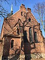
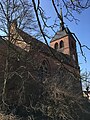
church building in Niebel (Treuenbrietzen), Germany  | |||||
| Upload media | |||||
| Instance of | |||||
|---|---|---|---|---|---|
| Location | Treuenbrietzen, Potsdam-Mittelmark District, Brandenburg, Germany | ||||
| Heritage designation | |||||
 | |||||
This is the category of the Brandenburger Baudenkmal (cultural heritage monument) with the ID 09190779 (Wikidata)
|
Media in category "Dorfkirche Niebel"
The following 17 files are in this category, out of 17 total.
-
 Dorfkirche Niebel Altar (FoP-Germany).jpg 1,629 × 1,653; 824 KB
-
 Dorfkirche Niebel Chor Nordostansicht.jpg 3,024 × 4,032; 5.21 MB
-
 Dorfkirche Niebel Chor Südansicht.jpg 3,024 × 4,032; 4.95 MB
-
 Dorfkirche Niebel Chor.jpg 3,024 × 4,032; 4.71 MB
-
 Dorfkirche Niebel Kirchenschiff Nordansicht.jpg 4,032 × 3,024; 3.71 MB
-
 Dorfkirche Niebel Nordostansicht.jpg 3,024 × 4,032; 4.56 MB
-
 Dorfkirche Niebel Ostansicht.jpg 3,024 × 4,032; 5.52 MB
-
 Dorfkirche Niebel Südansicht.jpg 4,032 × 3,024; 3.79 MB
-
 Dorfkirche Niebel Südostansicht März 2018.jpg 3,024 × 4,032; 5.69 MB
-
 Dorfkirche Niebel Südostansicht.jpg 4,032 × 3,024; 5.85 MB
-
 Dorfkirche Niebel Südwestansicht.jpg 4,032 × 3,024; 3.07 MB
-
 Dorfkirche Niebel Westansicht.jpg 3,024 × 4,032; 3.17 MB
-
 Dorfkirche Niebel Westturm Nordansicht.jpg 3,024 × 4,032; 1.58 MB
-
 Dorfkirche Niebel Westturm Nordportal.jpg 3,024 × 4,032; 3.85 MB
-
 Dorfkirche Niebel Westturm Südansicht.jpg 3,024 × 4,032; 5.38 MB
-
 Dorfkirche Niebel Westturm Westansicht.jpg 3,024 × 4,032; 2.79 MB
-
 Treuenbrietzen Niebel Dorfstraße Kirche.jpg 4,032 × 3,024; 4.76 MB
.jpg)


