Category:Dorfkirche Parey (Havelland)
Jump to navigation
Jump to search
|
Dorfkirche Parey (Havelland) has an entry on OpenStreetMap (show). |
| Object location | | View all coordinates using: OpenStreetMap |
|---|
church building in Havelaue, Brandenburg state, Germany _church_2016_NNE.jpg) | |||||
| Upload media | |||||
| Instance of | |||||
|---|---|---|---|---|---|
| Location | Parey (Havelaue), Havelaue, Havelland District, Brandenburg, Germany | ||||
| Heritage designation | |||||
| Inception |
| ||||
 | |||||
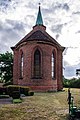
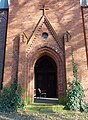
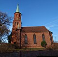
This is the category of the Brandenburger Baudenkmal (cultural heritage monument) with the ID 09150998 (Wikidata)
|
Deutsch: Dorfkirche in Parey, Gemeinde Havelaue, Landkreis Havelland, Land Brandenburg, Deutschland.
Français : Église de Parey, commune de Havelaue, arrondissement Pays de la Havel, état fédéral de Brandebourg, Allemagne
Media in category "Dorfkirche Parey (Havelland)"
The following 11 files are in this category, out of 11 total.
-
 Dorfkirche Parey-Havel 01.jpg 567 × 854; 120 KB
-
 Dorfkirche Parey-Havel 02.jpg 1,138 × 756; 136 KB
-
 Dorfkirche Parey-Havel 03.jpg 756 × 756; 129 KB
-
 Dorfkirche Parey-Havel 04.jpg 854 × 567; 153 KB
-
 Dorfkirche Parey-Havel 05.jpg 1,008 × 567; 118 KB
-
 Parey (Havelland) church 2016 E.jpg 3,648 × 4,864; 6.51 MB
-
 Parey (Havelland) church 2016 NE.jpg 4,856 × 4,719; 8.33 MB
-
 Parey (Havelland) church 2016 NNE.jpg 4,864 × 3,648; 5.51 MB
-
 Parey (Havelland) church 2016 portal W.jpg 3,460 × 4,726; 6.07 MB
-
 Parey (Havelland) church 2016 S.jpg 4,502 × 4,382; 8.19 MB
-
 Parey (Havelland) church 2016 SE.jpg 3,232 × 3,741; 5 MB


_church_2016_E.jpg)
_church_2016_NE.jpg)
_church_2016_portal_W.jpg)
_church_2016_S.jpg)
_church_2016_SE.jpg)