Category:Dorfkirche Petershagen
Jump to navigation
Jump to search
| Object location | | View all coordinates using: OpenStreetMap |
|---|
 | |||||
| Upload media | |||||
| Instance of | |||||
|---|---|---|---|---|---|
| Location | Petershagen, Zeschdorf, Märkisch-Oderland District, Brandenburg, Germany | ||||
| Heritage designation | |||||
 | |||||
This is the category of the Brandenburger Baudenkmal (cultural heritage monument) with the ID 09180604 (Wikidata)
|
Deutsch: Bilder der Kirche in Petershagen, Gemeinde Zeschdorf, Landkreis Märkisch-Oderland, Land Brandenburg, Deutschland.
English: Pictures of the church in Petershagen, Zeschdorf municipality, Märkisch-Oderland district, Brandenburg state, Germany
Français : Photos de l'église à Petershagen, commune de Zeschdorf, arrondissement de Märkisch-Oderland, état fédéral de Brandebourg, Allemagne
Media in category "Dorfkirche Petershagen"
The following 4 files are in this category, out of 4 total.
-
 Dorfkirche Petershagen.JPG 4,000 × 3,000; 4.2 MB
-
 Petershagen Kirche Altar Lebus Tafel 27.jpg 4,194 × 6,271; 16.51 MB
-
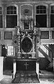 Petershagen Kirche Altar.jpg 2,988 × 4,645; 5.49 MB
-
 Sauer-Orgel Petershagen.JPG 3,000 × 4,000; 2.07 MB


