Category:Dorfkirche Pinnow (Gerswalde)
Jump to navigation
Jump to search
| Object location | | View all coordinates using: OpenStreetMap |
|---|
  | |||||
| Upload media | |||||
| Instance of | |||||
|---|---|---|---|---|---|
| Location | Pinnow, Gerswalde, Uckermark District, Brandenburg, Germany | ||||
| Heritage designation | |||||
 | |||||
This is the category of the Brandenburger Baudenkmal (cultural heritage monument) with the ID 09130581 (Wikidata)
|
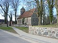
English: Church in Pinnow, Gerswalde municipality, Uckermark district, Brandenburg state, Germany. It is owned by a congregation within the Evangelical Church of Berlin-Brandenburg-Silesian Upper Lusatia, a united Protestant church body of Calvinist, Lutheran and united congregations. The church was erected in the 2nd half in the 13th c. Its octogonal spire was added in 1732.
Deutsch: Kirche in Pinnow, Gemeinde Gerswalde, Landkreis Uckermark, Land Brandenburg, Deutschland. Sie gehört einer Gemeinde der unierten Evangelischen Kirche Berlin-Brandenburg-Schlesische Oberlausitz. Die Kirche entstand in der 2. Hälfte des 13. Jh.s. Sie erhielt 1732 einen oktogonalen Turm.
Français : Église de Pinnow, commune de Gerswalde, arrondissement Uckermark, état fédéral de Brandebourg, Allemagne
Media in category "Dorfkirche Pinnow (Gerswalde)"
The following 4 files are in this category, out of 4 total.
-
-
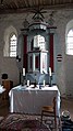 Kanzelaltar der Pinnower Kirche.jpg 720 × 1,280; 252 KB
-
 Loge der Pinnower Kirche.jpg 1,280 × 720; 204 KB
-
 PinnowGerswalde 04 16 03 jiw.jpg 1,920 × 1,280; 1.31 MB

