Category:Dorfkirche Porep
Jump to navigation
Jump to search
| Object location | | View all coordinates using: OpenStreetMap |
|---|
church building in Prignitz district, Brandenburg state, Germany  | |||||
| Upload media | |||||
| Instance of | |||||
|---|---|---|---|---|---|
| Location | Porep, Putlitz, Prignitz District, Brandenburg, Germany | ||||
| Heritage designation | |||||
 | |||||
This is the category of the Brandenburger Baudenkmal (cultural heritage monument) with the ID 09160444 (Wikidata)
|
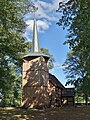
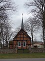
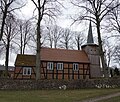
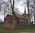
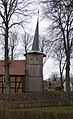
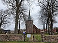
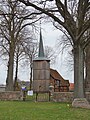
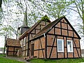
Deutsch: Die Dorfkirche in Porep, Landkreis Prignitz, Brandenburg, Deutschland. Die Kirche ist ein rechteckiger Fachwerkbau aus der ersten Hälfte de 18. Jahrhunderts, der Fachwerkanbau im Osten stammt von 1967. Der geböschte und verschieferte Glockenturm im Westen entstand um 1600-10 und ist bekrönt von einem spitzen achtseitigen Knickhelm. Datierung des Kirchenschiffs: ungenau, zwischen „nach 1733 (d)“ und „um/nach 1745 (d)“, letzter Wert dendrochronologisch bestätigt.
English: Village church in Porep, Putlitz municipality, Prignitz district, Brandenburg state, Germany
Français : Église de Porep, ville de Putlitz, arrondissement Prignitz, état fédéral de Brandebourg, Allemagne
Subcategories
This category has only the following subcategory.
I
- Interior of Dorfkirche Porep (5 F)
Pages in category "Dorfkirche Porep"
This category contains only the following page.
Media in category "Dorfkirche Porep"
The following 24 files are in this category, out of 24 total.
-
 Dorfkirche Porep 2016 Portal S.jpg 3,648 × 4,864; 6.46 MB
-
 Dorfkirche Porep 2016 SW.jpg 3,648 × 4,864; 9.06 MB
-
 Dorfkirche Porep 2021 E.jpg 3,648 × 4,864; 7.34 MB
-
 Dorfkirche Porep 2021 Fenster.jpg 3,648 × 4,864; 5.36 MB
-
 Dorfkirche Porep 2021 N.jpg 4,928 × 4,193; 11.26 MB
-
 Dorfkirche Porep 2021 NE.jpg 3,833 × 3,613; 8.26 MB
-
 Dorfkirche Porep 2021 SE.jpg 3,648 × 4,864; 7.86 MB
-
 Dorfkirche Porep 2021 SSE.jpg 4,864 × 3,648; 7.44 MB
-
 Dorfkirche Porep 2021 Turm.jpg 2,435 × 3,976; 5.74 MB
-
 Dorfkirche Porep 2021 Turmhaube.jpg 3,648 × 4,864; 7.22 MB
-
 Dorfkirche Porep 2021 W.jpg 3,769 × 2,827; 4.78 MB
-
 Dorfkirche Porep 2021 WNW.jpg 3,024 × 4,032; 6.54 MB
-
 Dorfkirche Porep 2021 WSW.jpg 3,648 × 4,864; 9.59 MB
-
 Dorfkirche Porep Anbau Nordansicht.jpg 4,032 × 3,024; 5.36 MB
-
 Dorfkirche Porep Nordansicht.jpg 4,032 × 3,024; 5.78 MB
-
 Dorfkirche Porep Nordostansicht.jpg 3,024 × 4,032; 5.1 MB
-
 Dorfkirche Porep Ostansicht.jpg 4,032 × 3,024; 5.13 MB
-
 Dorfkirche Porep Südansicht.jpg 4,032 × 3,024; 5.96 MB
-
 Dorfkirche Porep Südostansicht.jpg 4,032 × 3,024; 6.23 MB
-
 Dorfkirche Porep Westturm Nordansicht.jpg 3,024 × 4,032; 5.01 MB
-
 Dorfkirche Porep Westturm Nordwestansicht.jpg 3,024 × 4,032; 4.37 MB
-
 Dorfkirche Porep Westturm Westansicht.jpg 3,024 × 4,032; 4.88 MB
-
 Porep Kirche 2008-05-05 2.jpg 1,117 × 1,440; 593 KB
-
 Porep Kirche 2008-05-05.jpg 1,600 × 1,200; 1.61 MB


