Category:Dorfkirche Rohrlack
Jump to navigation
Jump to search
| Object location | | View all coordinates using: OpenStreetMap |
|---|
church building in Temnitztal, Brandenburg state, Germany  | |||||
| Upload media | |||||
| Instance of | |||||
|---|---|---|---|---|---|
| Location | Rohrlack, Temnitztal, Ostprignitz-Ruppin District, Brandenburg, Germany | ||||
| Street address |
| ||||
| Heritage designation | |||||
 | |||||
This is the category of the Brandenburger Baudenkmal (cultural heritage monument) with the ID 09170409 (Wikidata)
|
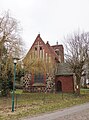
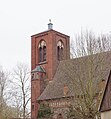
English: Pictures of the church in Rohrlack, Temnitztal municipality, Ostprignitz-Ruppin district, Brandenburg state, Germany.
Deutsch: Ansichten der Kirche in Rohrlack, Gemeinde Temnitztal, Landkreis Ostprignitz-Ruppin, Land Brandenburg, Deutschland.
Français : Photos de l'église à Rohrlack, commune de Temnitztal, arrondissement de Ostprignitz-Ruppin, état fédéral de Brandebourg, Allemagne
Español: Vistas de la iglesia en Rohrlack, municipio de Temnitztal, distrito de Ostprignitz-Ruppin, estado federado de Brandeburgo, Alemania
Address:
Barsikower Weg 1, Rohrlack, 16845 Temnitztal
Pages in category "Dorfkirche Rohrlack"
This category contains only the following page.
Media in category "Dorfkirche Rohrlack"
The following 7 files are in this category, out of 7 total.
-
 Rohrlack cemetery gate 2016.JPG 4,864 × 3,648; 8 MB
-
 Rohrlack church 2016 E.JPG 3,574 × 4,810; 7.41 MB
-
 Rohrlack church 2016 N.JPG 4,864 × 3,648; 10.28 MB
-
 Rohrlack church 2016 NW.JPG 4,864 × 3,648; 10.71 MB
-
 Rohrlack church 2016 S.JPG 4,864 × 3,648; 7.97 MB
-
 Rohrlack church 2016 SE.JPG 3,648 × 3,925; 6.12 MB
-
 Rohrlack church 2016 SSE.jpg 7,002 × 3,532; 11.39 MB


