Category:Dorfkirche Schmetzdorf
Jump to navigation
Jump to search
| Object location | | View all coordinates using: OpenStreetMap |
|---|
This is the category of the Brandenburger Baudenkmal (cultural heritage monument) with the ID 09150401 (Wikidata)
|
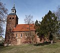
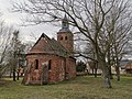
English: Church in Schmetzdorf, Milower Land municipality, Havelland district, Brandenburg state, Germany.
Deutsch: Dorfkirche in Schmetzdorf, Gemeinde Milower Land, Landkreis Havelland, Land Brandenburg, Deutschland.
Français : Église de Schmetzdorf, commune de Milower Land, arrondissement Pays de la Havel, état fédéral de Brandebourg, Allemagne
church building in Milower Land, Brandenburg state, Germany  | |||||
| Upload media | |||||
| Instance of | |||||
|---|---|---|---|---|---|
| Location | Schmetzdorf, Milower Land, Havelland District, Brandenburg, Germany | ||||
| Heritage designation | |||||
| Inception |
| ||||
 | |||||
Media in category "Dorfkirche Schmetzdorf"
The following 19 files are in this category, out of 19 total.
-
 Dorfkirche Schmetzdorf 2017 E.jpg 3,648 × 4,864; 6.06 MB
-
 Dorfkirche Schmetzdorf 2017 NE.jpg 2,575 × 3,559; 5.03 MB
-
 Dorfkirche Schmetzdorf 2017 Portal W.jpg 3,648 × 4,864; 7.33 MB
-
 Dorfkirche Schmetzdorf 2017 S.jpg 5,055 × 4,449; 11.59 MB
-
 Dorfkirche Schmetzdorf 2017 Turmhaube.jpg 3,648 × 4,864; 2.94 MB
-
 Dorfkirche Schmetzdorf 2017 vermauertes Portal S.jpg 3,648 × 4,864; 7.64 MB
-
 Dorfkirche Schmetzdorf 2017 W.jpg 3,648 × 4,864; 10.4 MB
-
 Dorfkirche Schmetzdorf (aus Nordosten).jpg 3,648 × 2,736; 4.01 MB
-
 Dorfkirche Schmetzdorf (Südseite).jpg 3,648 × 2,736; 3.9 MB
-
 Dorfkirche schmetzdorf 2020-02-09 10.jpg 5,120 × 3,840; 8.29 MB
-
 Dorfkirche schmetzdorf 2020-02-09 2.jpg 3,648 × 2,736; 4.53 MB
-
 Dorfkirche schmetzdorf 2020-02-09 3.jpg 3,648 × 2,736; 5.76 MB
-
 Dorfkirche schmetzdorf 2020-02-09 4.jpg 3,648 × 2,736; 5.89 MB
-
 Dorfkirche schmetzdorf 2020-02-09 5.jpg 3,648 × 2,736; 5.82 MB
-
 Dorfkirche schmetzdorf 2020-02-09 6.jpg 5,120 × 3,840; 6.65 MB
-
 Dorfkirche schmetzdorf 2020-02-09 7.jpg 3,840 × 5,120; 7.32 MB
-
 Dorfkirche schmetzdorf 2020-02-09 8.jpg 3,840 × 5,120; 7.53 MB
-
 Dorfkirche schmetzdorf 2020-02-09 9.jpg 3,840 × 5,120; 8.01 MB
-
 Dorfkirche schmetzdorf 2020-02-09.jpg 3,648 × 2,736; 3.46 MB


.jpg)
.jpg)


